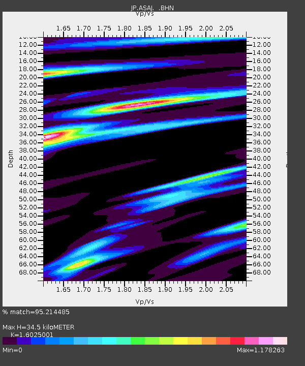
ASAJ Kamikawa Asahi - Earthquake Result Viewer

Earthquake location: Off W Coast Of Northern Sumatra
Earthquake latitude/longitude: 2.8/96.0
Earthquake time(UTC): 2008/02/20 (051) 08:08:30 GMT
Earthquake Depth: 26 km
Earthquake Magnitude: 6.5 MB, 7.5 MS, 7.4 MW, 7.4 MW
Earthquake Catalog/Contributor: WHDF/NEIC
Network: JP Japan Meteorological Agency Seismic Network
Station: ASAJ Kamikawa Asahi
Lat/Lon: 44.12 N/142.59 E
Elevation: 220 m
Distance: 58.2 deg
Az: 38.038 deg
Baz: 238.709 deg
Ray Param: 0.06297592
Estimated Moho Depth: 34.5 km
Estimated Crust Vp/Vs: 1.60
Assumed Crust Vp: 6.183 km/s
Estimated Crust Vs: 3.858 km/s
Estimated Crust Poisson's Ratio: 0.18
Radial Match: 95.214485 %
Radial Bump: 400
Transverse Match: 82.01834 %
Transverse Bump: 400
SOD ConfigId: 2564
Insert Time: 2010-03-09 12:10:03.812 +0000
GWidth: 2.5
Max Bumps: 400
Tol: 0.001

Signal To Noise

ChannelStoNSTALTA
JP:ASAJ: :BHN:20080220T08:17:51.249004Z3.32794365.4644505E-71.6419902E-7
JP:ASAJ: :BHE:20080220T08:17:51.249004Z6.65878441.2536877E-61.8827576E-7
JP:ASAJ: :BHZ:20080220T08:17:51.249004Z12.6030573.2792236E-62.601927E-7
Arrivals
Ps3.5 SECOND
PpPs14 SECOND
PsPs/PpSs17 SECOND