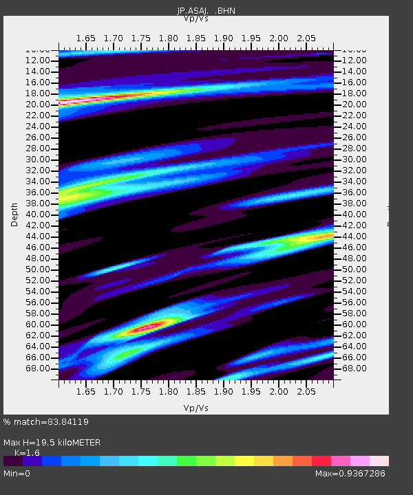
ASAJ Kamikawa Asahi - Earthquake Result Viewer

Earthquake location: Southeast Of Loyalty Islands
Earthquake latitude/longitude: -22.7/171.0
Earthquake time(UTC): 2009/01/21 (021) 17:08:42 GMT
Earthquake Depth: 24 km
Earthquake Magnitude: 5.8 MS, 5.4 MB, 6.1 MW, 6.1 MW
Earthquake Catalog/Contributor: WHDF/NEIC
Network: JP Japan Meteorological Agency Seismic Network
Station: ASAJ Kamikawa Asahi
Lat/Lon: 44.12 N/142.59 E
Elevation: 220 m
Distance: 71.4 deg
Az: 338.777 deg
Baz: 152.343 deg
Ray Param: 0.054316416
Estimated Moho Depth: 19.5 km
Estimated Crust Vp/Vs: 1.60
Assumed Crust Vp: 6.183 km/s
Estimated Crust Vs: 3.864 km/s
Estimated Crust Poisson's Ratio: 0.18
Radial Match: 83.84119 %
Radial Bump: 400
Transverse Match: 48.373623 %
Transverse Bump: 400
SOD ConfigId: 2834
Insert Time: 2010-03-09 12:10:09.632 +0000
GWidth: 2.5
Max Bumps: 400
Tol: 0.001

Signal To Noise

ChannelStoNSTALTA
JP:ASAJ: :BHN:20090121T17:19:29.950022Z3.82147846.349559E-71.6615452E-7
JP:ASAJ: :BHE:20090121T17:19:29.950022Z1.17695752.4221697E-72.0579924E-7
JP:ASAJ: :BHZ:20090121T17:19:29.950022Z2.15285833.0925455E-71.4364836E-7
Arrivals
Ps2.0 SECOND
PpPs7.9 SECOND
PsPs/PpSs9.9 SECOND