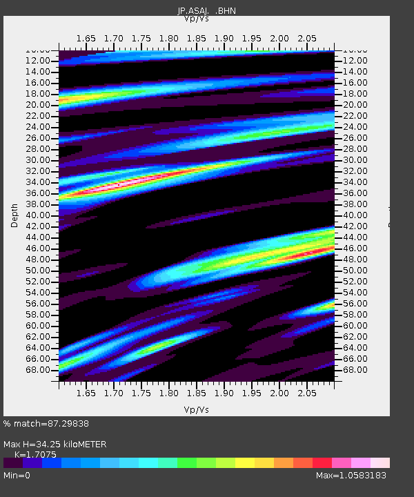
ASAJ Kamikawa Asahi - Earthquake Result Viewer

Earthquake location: Southern Sumatra, Indonesia
Earthquake latitude/longitude: -2.0/100.1
Earthquake time(UTC): 2007/09/20 (263) 08:31:14 GMT
Earthquake Depth: 30 km
Earthquake Magnitude: 6.3 MB, 6.8 MS, 6.7 MW, 6.3 ME
Earthquake Catalog/Contributor: WHDF/NEIC
Network: JP Japan Meteorological Agency Seismic Network
Station: ASAJ Kamikawa Asahi
Lat/Lon: 44.12 N/142.59 E
Elevation: 220 m
Distance: 59.5 deg
Az: 34.334 deg
Baz: 231.503 deg
Ray Param: 0.062076837
Estimated Moho Depth: 34.25 km
Estimated Crust Vp/Vs: 1.71
Assumed Crust Vp: 6.183 km/s
Estimated Crust Vs: 3.621 km/s
Estimated Crust Poisson's Ratio: 0.24
Radial Match: 87.29838 %
Radial Bump: 400
Transverse Match: 81.55776 %
Transverse Bump: 400
SOD ConfigId: 2564
Insert Time: 2010-03-09 12:10:16.380 +0000
GWidth: 2.5
Max Bumps: 400
Tol: 0.001

Signal To Noise

ChannelStoNSTALTA
JP:ASAJ: :BHN:20070920T08:40:44.200022Z2.3000912.2327863E-79.707382E-8
JP:ASAJ: :BHE:20070920T08:40:44.200022Z2.81394123.869748E-71.3752056E-7
JP:ASAJ: :BHZ:20070920T08:40:44.200022Z6.341711.0844656E-61.7100523E-7
Arrivals
Ps4.1 SECOND
PpPs14 SECOND
PsPs/PpSs18 SECOND