You are here: Home > Network List > AK - Alaska Regional Network Stations List
> Station H16K Elim, AK, USA > Earthquake Result Viewer
H16K Elim, AK, USA - Earthquake Result Viewer
| Earthquake location: |
Kermadec Islands, New Zealand |
| Earthquake latitude/longitude: |
-30.0/-177.5 |
| Earthquake time(UTC): |
2021/08/31 (243) 02:52:49 GMT |
| Earthquake Depth: |
10 km |
| Earthquake Magnitude: |
6.3 mww |
| Earthquake Catalog/Contributor: |
NEIC PDE/us |
|
| Network: |
AK Alaska Regional Network |
| Station: |
H16K Elim, AK, USA |
| Lat/Lon: |
64.64 N/162.24 W |
| Elevation: |
216 m |
|
| Distance: |
95.0 deg |
| Az: |
6.541 deg |
| Baz: |
193.27 deg |
| Ray Param: |
0.04089627 |
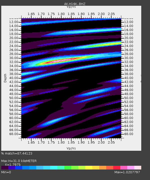
| Estimated Moho Depth: |
31.0 km |
| Estimated Crust Vp/Vs: |
1.80 |
| Assumed Crust Vp: |
6.276 km/s |
| Estimated Crust Vs: |
3.491 km/s |
| Estimated Crust Poisson's Ratio: |
0.28 |
|
| Radial Match: |
87.44123 % |
| Radial Bump: |
400 |
| Transverse Match: |
79.577896 % |
| Transverse Bump: |
400 |
| SOD ConfigId: |
25131211 |
| Insert Time: |
2021-09-14 03:09:34.983 +0000 |
| GWidth: |
2.5 |
| Max Bumps: |
400 |
| Tol: |
0.001 |
|

Signal To Noise
| Channel | StoN | STA | LTA |
| AK:H16K: :BHZ:20210831T03:05:40.739988Z | 8.613845 | 4.449279E-7 | 5.1652645E-8 |
| AK:H16K: :BHN:20210831T03:05:40.739988Z | 4.3986077 | 1.5799982E-7 | 3.5920415E-8 |
| AK:H16K: :BHE:20210831T03:05:40.739988Z | 2.2619417 | 9.5198935E-8 | 4.208726E-8 |
| Arrivals |
| Ps | 4.0 SECOND |
| PpPs | 14 SECOND |
| PsPs/PpSs | 18 SECOND |


