You are here: Home > Network List > JP - Japan Meteorological Agency Seismic Network Stations List
> Station ASAJ Kamikawa Asahi > Earthquake Result Viewer
ASAJ Kamikawa Asahi - Earthquake Result Viewer
| Earthquake location: |
Southern Sumatra, Indonesia |
| Earthquake latitude/longitude: |
-0.7/99.9 |
| Earthquake time(UTC): |
2009/09/30 (273) 10:16:09 GMT |
| Earthquake Depth: |
81 km |
| Earthquake Magnitude: |
7.1 MB, 7.5 MW, 7.5 MW |
| Earthquake Catalog/Contributor: |
WHDF/NEIC |
|
| Network: |
JP Japan Meteorological Agency Seismic Network |
| Station: |
ASAJ Kamikawa Asahi |
| Lat/Lon: |
44.12 N/142.59 E |
| Elevation: |
220 m |
|
| Distance: |
58.6 deg |
| Az: |
34.908 deg |
| Baz: |
232.607 deg |
| Ray Param: |
0.06248899 |
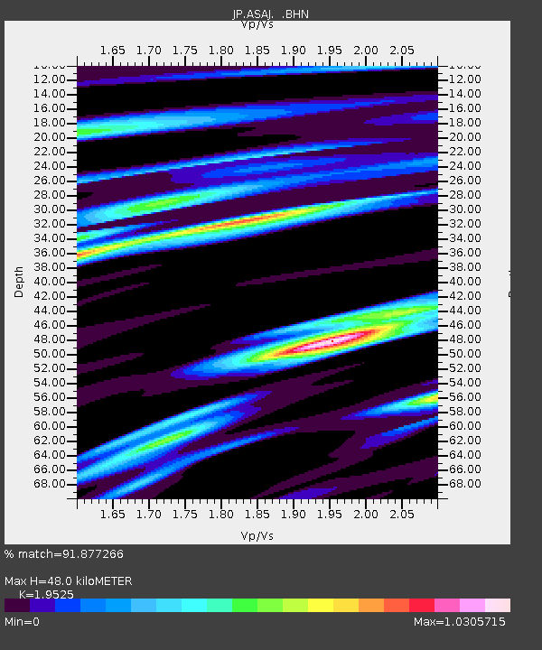
| Estimated Moho Depth: |
48.0 km |
| Estimated Crust Vp/Vs: |
1.95 |
| Assumed Crust Vp: |
6.183 km/s |
| Estimated Crust Vs: |
3.167 km/s |
| Estimated Crust Poisson's Ratio: |
0.32 |
|
| Radial Match: |
91.877266 % |
| Radial Bump: |
400 |
| Transverse Match: |
89.09121 % |
| Transverse Bump: |
400 |
| SOD ConfigId: |
2622 |
| Insert Time: |
2010-03-09 12:10:56.124 +0000 |
| GWidth: |
2.5 |
| Max Bumps: |
400 |
| Tol: |
0.001 |
|

Signal To Noise
| Channel | StoN | STA | LTA |
| JP:ASAJ: :BHN:20090930T10:25:27.348999Z | 81.66193 | 5.3315773E-5 | 6.528841E-7 |
| JP:ASAJ: :BHE:20090930T10:25:27.348999Z | 42.190693 | 1.1503086E-5 | 2.726451E-7 |
| JP:ASAJ: :BHZ:20090930T10:25:27.348999Z | 54.485786 | 2.0208032E-5 | 3.708863E-7 |
| Arrivals |
| Ps | 7.7 SECOND |
| PpPs | 22 SECOND |
| PsPs/PpSs | 30 SECOND |


