You are here: Home > Network List > AV - Alaska Volcano Observatory Stations List
> Station AUJK Augustine Jurgen Kienle, Cook Inlet, Alaska > Earthquake Result Viewer
AUJK Augustine Jurgen Kienle, Cook Inlet, Alaska - Earthquake Result Viewer
| Earthquake location: |
Kermadec Islands, New Zealand |
| Earthquake latitude/longitude: |
-30.0/-177.5 |
| Earthquake time(UTC): |
2021/08/31 (243) 02:52:49 GMT |
| Earthquake Depth: |
10 km |
| Earthquake Magnitude: |
6.3 mww |
| Earthquake Catalog/Contributor: |
NEIC PDE/us |
|
| Network: |
AV Alaska Volcano Observatory |
| Station: |
AUJK Augustine Jurgen Kienle, Cook Inlet, Alaska |
| Lat/Lon: |
59.35 N/153.41 W |
| Elevation: |
377 m |
|
| Distance: |
91.2 deg |
| Az: |
12.08 deg |
| Baz: |
200.763 deg |
| Ray Param: |
0.041636057 |
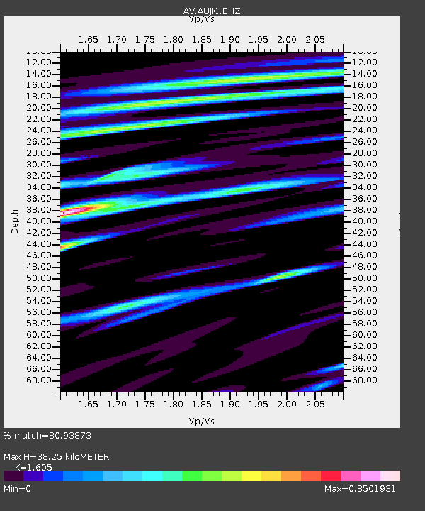
| Estimated Moho Depth: |
38.25 km |
| Estimated Crust Vp/Vs: |
1.61 |
| Assumed Crust Vp: |
5.989 km/s |
| Estimated Crust Vs: |
3.732 km/s |
| Estimated Crust Poisson's Ratio: |
0.18 |
|
| Radial Match: |
80.93873 % |
| Radial Bump: |
400 |
| Transverse Match: |
81.337654 % |
| Transverse Bump: |
400 |
| SOD ConfigId: |
25131211 |
| Insert Time: |
2021-09-14 03:13:05.832 +0000 |
| GWidth: |
2.5 |
| Max Bumps: |
400 |
| Tol: |
0.001 |
|
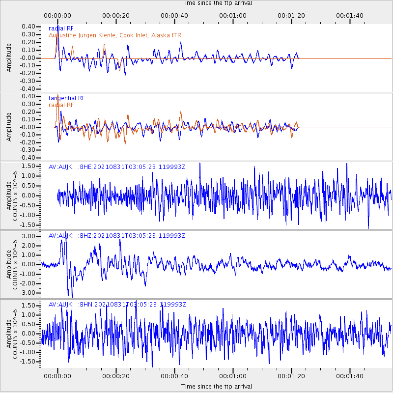
Signal To Noise
| Channel | StoN | STA | LTA |
| AV:AUJK: :BHZ:20210831T03:05:23.119993Z | 13.123672 | 1.616347E-6 | 1.2316272E-7 |
| AV:AUJK: :BHN:20210831T03:05:23.119993Z | 2.1541548 | 7.600537E-7 | 3.5283153E-7 |
| AV:AUJK: :BHE:20210831T03:05:23.119993Z | 1.4803023 | 4.7569378E-7 | 3.2134906E-7 |
| Arrivals |
| Ps | 3.9 SECOND |
| PpPs | 16 SECOND |
| PsPs/PpSs | 20 SECOND |


