You are here: Home > Network List > AV - Alaska Volcano Observatory Stations List
> Station GSIG Igitkin Island, Great Sitkin Volcano, Alaska > Earthquake Result Viewer
GSIG Igitkin Island, Great Sitkin Volcano, Alaska - Earthquake Result Viewer
| Earthquake location: |
Kermadec Islands, New Zealand |
| Earthquake latitude/longitude: |
-30.0/-177.5 |
| Earthquake time(UTC): |
2021/08/31 (243) 02:52:49 GMT |
| Earthquake Depth: |
10 km |
| Earthquake Magnitude: |
6.3 mww |
| Earthquake Catalog/Contributor: |
NEIC PDE/us |
|
| Network: |
AV Alaska Volcano Observatory |
| Station: |
GSIG Igitkin Island, Great Sitkin Volcano, Alaska |
| Lat/Lon: |
51.99 N/175.93 W |
| Elevation: |
407 m |
|
| Distance: |
81.6 deg |
| Az: |
0.993 deg |
| Baz: |
181.393 deg |
| Ray Param: |
0.047476646 |
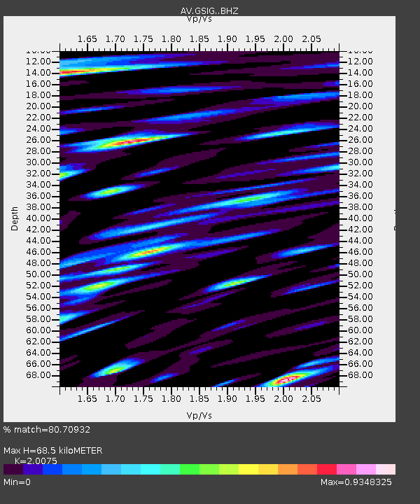
| Estimated Moho Depth: |
68.5 km |
| Estimated Crust Vp/Vs: |
2.01 |
| Assumed Crust Vp: |
3.943 km/s |
| Estimated Crust Vs: |
1.964 km/s |
| Estimated Crust Poisson's Ratio: |
0.33 |
|
| Radial Match: |
80.70932 % |
| Radial Bump: |
400 |
| Transverse Match: |
67.164375 % |
| Transverse Bump: |
400 |
| SOD ConfigId: |
25131211 |
| Insert Time: |
2021-09-14 03:13:29.066 +0000 |
| GWidth: |
2.5 |
| Max Bumps: |
400 |
| Tol: |
0.001 |
|
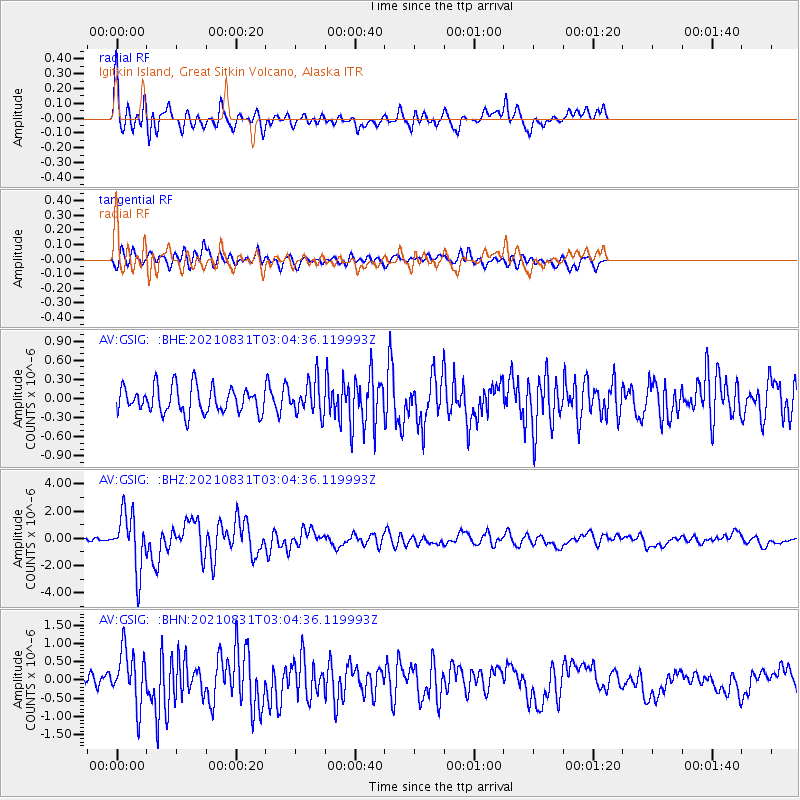
Signal To Noise
| Channel | StoN | STA | LTA |
| AV:GSIG: :BHZ:20210831T03:04:36.119993Z | 16.38511 | 2.0794976E-6 | 1.2691385E-7 |
| AV:GSIG: :BHN:20210831T03:04:36.119993Z | 3.7777357 | 7.618828E-7 | 2.0167711E-7 |
| AV:GSIG: :BHE:20210831T03:04:36.119993Z | 1.2741926 | 2.6030324E-7 | 2.0428878E-7 |
| Arrivals |
| Ps | 18 SECOND |
| PpPs | 52 SECOND |
| PsPs/PpSs | 69 SECOND |


