You are here: Home > Network List > AV - Alaska Volcano Observatory Stations List
> Station KIWB Westway Bight, Kanaga Volcano, Alaska > Earthquake Result Viewer
KIWB Westway Bight, Kanaga Volcano, Alaska - Earthquake Result Viewer
| Earthquake location: |
Kermadec Islands, New Zealand |
| Earthquake latitude/longitude: |
-30.0/-177.5 |
| Earthquake time(UTC): |
2021/08/31 (243) 02:52:49 GMT |
| Earthquake Depth: |
10 km |
| Earthquake Magnitude: |
6.3 mww |
| Earthquake Catalog/Contributor: |
NEIC PDE/us |
|
| Network: |
AV Alaska Volcano Observatory |
| Station: |
KIWB Westway Bight, Kanaga Volcano, Alaska |
| Lat/Lon: |
51.85 N/177.15 W |
| Elevation: |
244 m |
|
| Distance: |
81.5 deg |
| Az: |
0.227 deg |
| Baz: |
180.318 deg |
| Ray Param: |
0.047579046 |
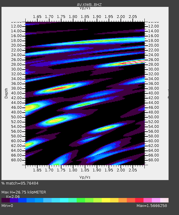
| Estimated Moho Depth: |
26.75 km |
| Estimated Crust Vp/Vs: |
2.06 |
| Assumed Crust Vp: |
5.88 km/s |
| Estimated Crust Vs: |
2.855 km/s |
| Estimated Crust Poisson's Ratio: |
0.35 |
|
| Radial Match: |
85.76484 % |
| Radial Bump: |
400 |
| Transverse Match: |
81.0975 % |
| Transverse Bump: |
400 |
| SOD ConfigId: |
25131211 |
| Insert Time: |
2021-09-14 03:13:58.907 +0000 |
| GWidth: |
2.5 |
| Max Bumps: |
400 |
| Tol: |
0.001 |
|
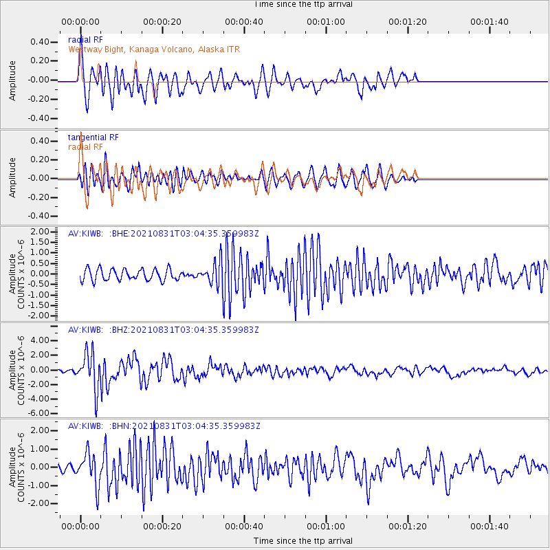
Signal To Noise
| Channel | StoN | STA | LTA |
| AV:KIWB: :BHZ:20210831T03:04:35.359983Z | 14.548957 | 2.5458E-6 | 1.7498162E-7 |
| AV:KIWB: :BHN:20210831T03:04:35.359983Z | 5.5686393 | 9.1593404E-7 | 1.6448077E-7 |
| AV:KIWB: :BHE:20210831T03:04:35.359983Z | 2.0330474 | 5.409406E-7 | 2.6607376E-7 |
| Arrivals |
| Ps | 4.9 SECOND |
| PpPs | 14 SECOND |
| PsPs/PpSs | 19 SECOND |


