You are here: Home > Network List > AV - Alaska Volcano Observatory Stations List
> Station MAPS Pakushin Southeast, Makushin Volcano, Alaska > Earthquake Result Viewer
MAPS Pakushin Southeast, Makushin Volcano, Alaska - Earthquake Result Viewer

| Earthquake location: |
Kermadec Islands, New Zealand |
| Earthquake latitude/longitude: |
-30.0/-177.5 |
| Earthquake time(UTC): |
2021/08/31 (243) 02:52:49 GMT |
| Earthquake Depth: |
10 km |
| Earthquake Magnitude: |
6.3 mww |
| Earthquake Catalog/Contributor: |
NEIC PDE/us |
|
| Network: |
AV Alaska Volcano Observatory |
| Station: |
MAPS Pakushin Southeast, Makushin Volcano, Alaska |
| Lat/Lon: |
53.81 N/166.94 W |
| Elevation: |
333 m |
|
| Distance: |
83.9 deg |
| Az: |
6.284 deg |
| Baz: |
189.216 deg |
| Ray Param: |
0.04584469 |
| Estimated Moho Depth: |
10.5 km |
| Estimated Crust Vp/Vs: |
1.64 |
| Assumed Crust Vp: |
3.943 km/s |
| Estimated Crust Vs: |
2.405 km/s |
| Estimated Crust Poisson's Ratio: |
0.20 |
|
| Radial Match: |
81.04497 % |
| Radial Bump: |
400 |
| Transverse Match: |
66.6706 % |
| Transverse Bump: |
400 |
| SOD ConfigId: |
25131211 |
| Insert Time: |
2021-09-14 03:14:17.657 +0000 |
| GWidth: |
2.5 |
| Max Bumps: |
400 |
| Tol: |
0.001 |
|
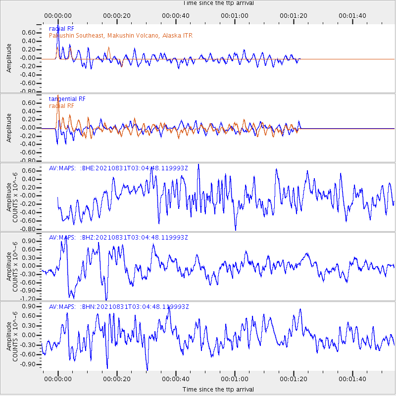
Signal To Noise
| Channel | StoN | STA | LTA |
| AV:MAPS: :BHZ:20210831T03:04:48.119993Z | 3.02092 | 6.883775E-7 | 2.2787015E-7 |
| AV:MAPS: :BHN:20210831T03:04:48.119993Z | 1.2032127 | 4.6220507E-7 | 3.8414242E-7 |
| AV:MAPS: :BHE:20210831T03:04:48.119993Z | 1.7612467 | 4.9901087E-7 | 2.8332823E-7 |
| Arrivals |
| Ps | 1.7 SECOND |
| PpPs | 7.0 SECOND |
| PsPs/PpSs | 8.7 SECOND |


