You are here: Home > Network List > JP - Japan Meteorological Agency Seismic Network Stations List
> Station ASAJ Kamikawa Asahi > Earthquake Result Viewer
ASAJ Kamikawa Asahi - Earthquake Result Viewer
| Earthquake location: |
Solomon Islands |
| Earthquake latitude/longitude: |
-10.6/163.1 |
| Earthquake time(UTC): |
2008/07/28 (210) 21:40:47 GMT |
| Earthquake Depth: |
10 km |
| Earthquake Magnitude: |
5.9 MB, 5.8 MS, 6.0 MW |
| Earthquake Catalog/Contributor: |
WHDF/NEIC |
|
| Network: |
JP Japan Meteorological Agency Seismic Network |
| Station: |
ASAJ Kamikawa Asahi |
| Lat/Lon: |
44.12 N/142.59 E |
| Elevation: |
220 m |
|
| Distance: |
57.5 deg |
| Az: |
342.598 deg |
| Baz: |
155.903 deg |
| Ray Param: |
0.06342674 |
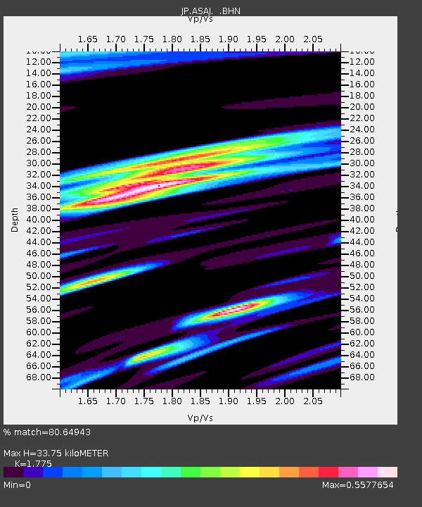
| Estimated Moho Depth: |
33.75 km |
| Estimated Crust Vp/Vs: |
1.77 |
| Assumed Crust Vp: |
6.183 km/s |
| Estimated Crust Vs: |
3.483 km/s |
| Estimated Crust Poisson's Ratio: |
0.27 |
|
| Radial Match: |
80.64943 % |
| Radial Bump: |
400 |
| Transverse Match: |
64.35409 % |
| Transverse Bump: |
400 |
| SOD ConfigId: |
2504 |
| Insert Time: |
2010-03-09 12:11:20.583 +0000 |
| GWidth: |
2.5 |
| Max Bumps: |
400 |
| Tol: |
0.001 |
|

Signal To Noise
| Channel | StoN | STA | LTA |
| JP:ASAJ: :BHN:20080728T21:50:05.849014Z | 2.8590696 | 6.8434474E-7 | 2.3935922E-7 |
| JP:ASAJ: :BHE:20080728T21:50:05.849014Z | 1.401019 | 3.24218E-7 | 2.3141585E-7 |
| JP:ASAJ: :BHZ:20080728T21:50:05.849014Z | 1.0595597 | 1.8068057E-7 | 1.705242E-7 |
| Arrivals |
| Ps | 4.4 SECOND |
| PpPs | 14 SECOND |
| PsPs/PpSs | 19 SECOND |


