You are here: Home > Network List > PF - Volcanologic Network of Piton de Fournaise-OVPF Stations List
> Station HIM cratere Himiltrude > Earthquake Result Viewer
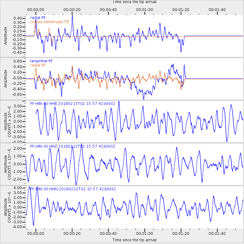
HIM cratere Himiltrude - Earthquake Result Viewer
*The percent match for this event was below the threshold and hence no stack was calculated.
| Earthquake location: |
South Of Mariana Islands |
| Earthquake latitude/longitude: |
13.8/146.7 |
| Earthquake time(UTC): |
2018/02/13 (044) 02:03:03 GMT |
| Earthquake Depth: |
10 km |
| Earthquake Magnitude: |
5.7 mww |
| Earthquake Catalog/Contributor: |
NEIC PDE/pt |
|
| Network: |
PF Volcanologic Network of Piton de Fournaise-OVPF |
| Station: |
HIM cratere Himiltrude |
| Lat/Lon: |
21.21 S/55.72 E |
| Elevation: |
1958 m |
|
| Distance: |
95.8 deg |
| Az: |
249.666 deg |
| Baz: |
77.455 deg |
| Ray Param: |
$rayparam |
*The percent match for this event was below the threshold and hence was not used in the summary stack. |
|
| Radial Match: |
40.010838 % |
| Radial Bump: |
400 |
| Transverse Match: |
65.98742 % |
| Transverse Bump: |
400 |
| SOD ConfigId: |
2546091 |
| Insert Time: |
2018-02-27 02:05:01.960 +0000 |
| GWidth: |
2.5 |
| Max Bumps: |
400 |
| Tol: |
0.001 |
|
Signal To Noise
| Channel | StoN | STA | LTA |
| PF:HIM:00:HHZ:20180213T02:15:57.429993Z | 0.48876202 | 5.8141757E-7 | 1.1895719E-6 |
| PF:HIM:00:HHN:20180213T02:15:57.429993Z | 1.3313844 | 2.1920882E-6 | 1.6464729E-6 |
| PF:HIM:00:HHE:20180213T02:15:57.429993Z | 0.47896153 | 8.4685723E-7 | 1.7681111E-6 |
| Arrivals |
| Ps | |
| PpPs | |
| PsPs/PpSs | |


