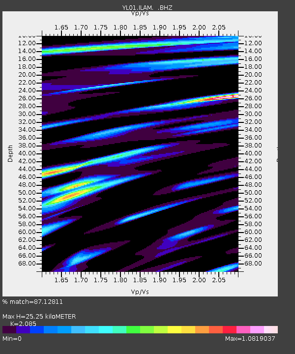
ILAM YL.ILAM - Earthquake Result Viewer
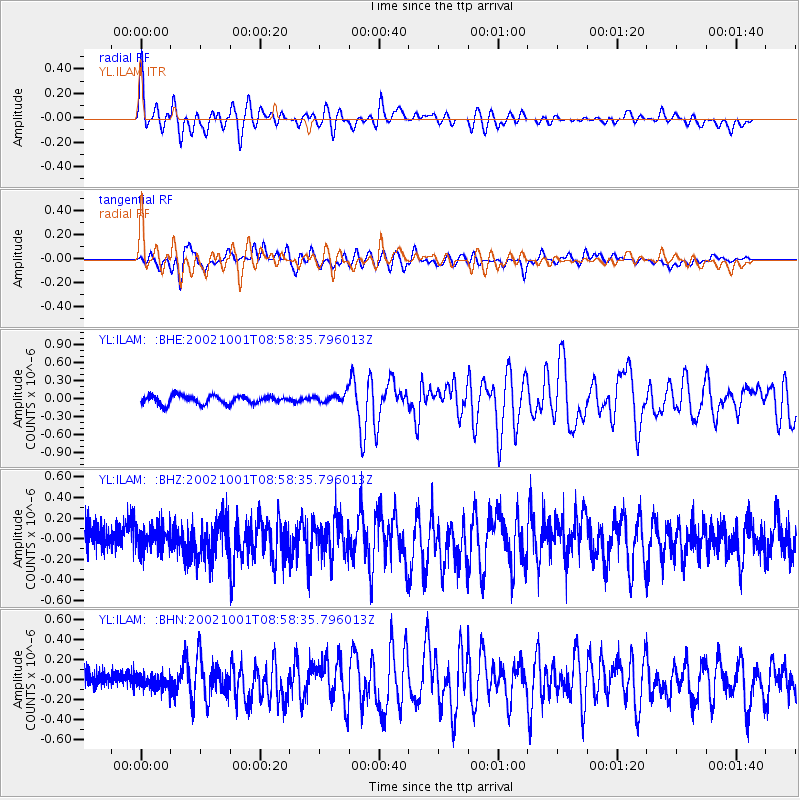
Earthquake location: Solomon Islands
Earthquake latitude/longitude: -10.9/161.2
Earthquake time(UTC): 2002/10/01 (274) 08:46:55 GMT
Earthquake Depth: 10 km
Earthquake Magnitude: 5.7 MB, 5.5 MS, 5.8 MW, 5.6 MW
Earthquake Catalog/Contributor: WHDF/NEIC
Network: YL Himalayan Nepal Tibet Experiment
Station: ILAM YL.ILAM
Lat/Lon: 26.91 N/87.92 E
Elevation: 1181 m
Distance: 80.4 deg
Az: 299.838 deg
Baz: 107.439 deg
Ray Param: 0.048327874
Estimated Moho Depth: 25.25 km
Estimated Crust Vp/Vs: 2.09
Assumed Crust Vp: 6.236 km/s
Estimated Crust Vs: 2.991 km/s
Estimated Crust Poisson's Ratio: 0.35
Radial Match: 87.12811 %
Radial Bump: 400
Transverse Match: 77.276 %
Transverse Bump: 400
SOD ConfigId: 16820
Insert Time: 2010-02-26 15:55:49.669 +0000
GWidth: 2.5
Max Bumps: 400
Tol: 0.001

Signal To Noise

ChannelStoNSTALTA
YL:ILAM: :BHZ:20021001T08:58:35.796013Z0.80161181.09401356E-71.3647674E-7
YL:ILAM: :BHN:20021001T08:58:35.796013Z0.717711036.479329E-89.027769E-8
YL:ILAM: :BHE:20021001T08:58:35.796013Z1.09695547.610702E-86.938023E-8
Arrivals
Ps4.5 SECOND
PpPs12 SECOND
PsPs/PpSs17 SECOND