You are here: Home > Network List > CC - Cascade Chain Volcano Monitoring Stations List
> Station BRSP Barrett Spur > Earthquake Result Viewer
BRSP Barrett Spur - Earthquake Result Viewer
| Earthquake location: |
Kermadec Islands, New Zealand |
| Earthquake latitude/longitude: |
-30.0/-177.5 |
| Earthquake time(UTC): |
2021/08/31 (243) 02:52:49 GMT |
| Earthquake Depth: |
10 km |
| Earthquake Magnitude: |
6.3 mww |
| Earthquake Catalog/Contributor: |
NEIC PDE/us |
|
| Network: |
CC Cascade Chain Volcano Monitoring |
| Station: |
BRSP Barrett Spur |
| Lat/Lon: |
45.40 N/121.71 W |
| Elevation: |
2080 m |
|
| Distance: |
90.5 deg |
| Az: |
35.645 deg |
| Baz: |
225.877 deg |
| Ray Param: |
0.041698452 |
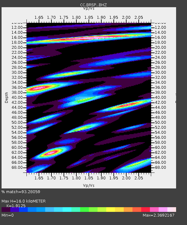
| Estimated Moho Depth: |
16.0 km |
| Estimated Crust Vp/Vs: |
1.91 |
| Assumed Crust Vp: |
6.597 km/s |
| Estimated Crust Vs: |
3.45 km/s |
| Estimated Crust Poisson's Ratio: |
0.31 |
|
| Radial Match: |
93.28059 % |
| Radial Bump: |
392 |
| Transverse Match: |
84.95094 % |
| Transverse Bump: |
400 |
| SOD ConfigId: |
25131211 |
| Insert Time: |
2021-09-14 03:17:23.887 +0000 |
| GWidth: |
2.5 |
| Max Bumps: |
400 |
| Tol: |
0.001 |
|

Signal To Noise
| Channel | StoN | STA | LTA |
| CC:BRSP: :BHZ:20210831T03:05:19.979978Z | 10.161324 | 1.3931782E-6 | 1.3710599E-7 |
| CC:BRSP: :BHN:20210831T03:05:19.979978Z | 3.056098 | 5.969971E-7 | 1.9534619E-7 |
| CC:BRSP: :BHE:20210831T03:05:19.979978Z | 1.6675398 | 4.6177445E-7 | 2.769196E-7 |
| Arrivals |
| Ps | 2.3 SECOND |
| PpPs | 6.9 SECOND |
| PsPs/PpSs | 9.2 SECOND |


