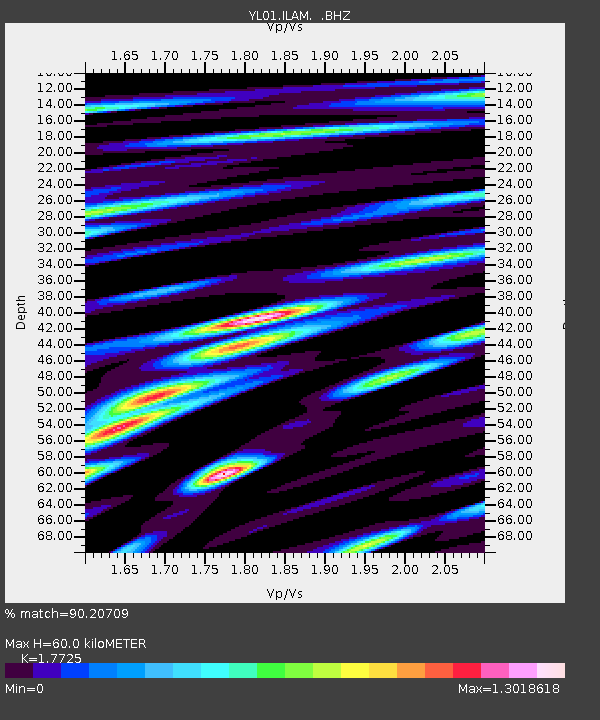
ILAM YL.ILAM - Earthquake Result Viewer
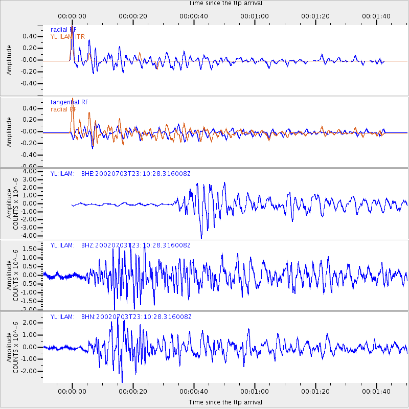
Earthquake location: Eastern New Guinea Reg., P.N.G.
Earthquake latitude/longitude: -5.0/147.3
Earthquake time(UTC): 2002/07/03 (184) 23:00:18 GMT
Earthquake Depth: 31 km
Earthquake Magnitude: 5.6 MB, 6.2 MS, 6.2 MW, 6.2 MW
Earthquake Catalog/Contributor: WHDF/NEIC
Network: YL Himalayan Nepal Tibet Experiment
Station: ILAM YL.ILAM
Lat/Lon: 26.91 N/87.92 E
Elevation: 1181 m
Distance: 65.6 deg
Az: 302.412 deg
Baz: 109.637 deg
Ray Param: 0.05812971
Estimated Moho Depth: 60.0 km
Estimated Crust Vp/Vs: 1.77
Assumed Crust Vp: 6.236 km/s
Estimated Crust Vs: 3.518 km/s
Estimated Crust Poisson's Ratio: 0.27
Radial Match: 90.20709 %
Radial Bump: 400
Transverse Match: 88.33614 %
Transverse Bump: 400
SOD ConfigId: 16820
Insert Time: 2010-02-26 15:55:52.635 +0000
GWidth: 2.5
Max Bumps: 400
Tol: 0.001

Signal To Noise

ChannelStoNSTALTA
YL:ILAM: :BHZ:20020703T23:10:28.316008Z0.97544451.006922E-71.0322699E-7
YL:ILAM: :BHN:20020703T23:10:28.316008Z1.12423181.1367462E-71.0111315E-7
YL:ILAM: :BHE:20020703T23:10:28.316008Z2.18107082.1700515E-79.949478E-8
Arrivals
Ps7.7 SECOND
PpPs26 SECOND
PsPs/PpSs33 SECOND