ILAM YL.ILAM - Earthquake Result Viewer
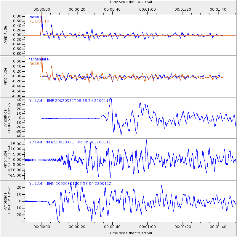
Earthquake location: Taiwan Region
Earthquake latitude/longitude: 24.3/122.2
Earthquake time(UTC): 2002/03/31 (090) 06:52:50 GMT
Earthquake Depth: 33 km
Earthquake Magnitude: 6.4 MB, 7.4 MS, 7.1 MW, 7.1 MW
Earthquake Catalog/Contributor: WHDF/NEIC
Network: YL Himalayan Nepal Tibet Experiment
Station: ILAM YL.ILAM
Lat/Lon: 26.91 N/87.92 E
Elevation: 1181 m
Distance: 31.0 deg
Az: 282.241 deg
Baz: 87.152 deg
Ray Param: 0.07916634
Estimated Moho Depth: 47.5 km
Estimated Crust Vp/Vs: 1.69
Assumed Crust Vp: 6.236 km/s
Estimated Crust Vs: 3.69 km/s
Estimated Crust Poisson's Ratio: 0.23
Radial Match: 92.923355 %
Radial Bump: 400
Transverse Match: 74.477486 %
Transverse Bump: 400
SOD ConfigId: 16820
Insert Time: 2010-02-26 15:55:58.550 +0000
GWidth: 2.5
Max Bumps: 400
Tol: 0.001

Signal To Noise

ChannelStoNSTALTA
YL:ILAM: :BHZ:20020331T06:58:34.220011Z0.69263091.6020175E-72.3129454E-7
YL:ILAM: :BHN:20020331T06:58:34.220011Z8.3944841.6932256E-62.0170694E-7
YL:ILAM: :BHE:20020331T06:58:34.220011Z22.8323612.9031298E-61.2714979E-7
Arrivals
Ps5.7 SECOND
PpPs19 SECOND
PsPs/PpSs25 SECOND