You are here: Home > Network List > IW - Intermountain West Stations List
> Station PLID Pearl Lake, Idaho, USA > Earthquake Result Viewer
PLID Pearl Lake, Idaho, USA - Earthquake Result Viewer

| Earthquake location: |
Kermadec Islands, New Zealand |
| Earthquake latitude/longitude: |
-30.0/-177.5 |
| Earthquake time(UTC): |
2021/08/31 (243) 02:52:49 GMT |
| Earthquake Depth: |
10 km |
| Earthquake Magnitude: |
6.3 mww |
| Earthquake Catalog/Contributor: |
NEIC PDE/us |
|
| Network: |
IW Intermountain West |
| Station: |
PLID Pearl Lake, Idaho, USA |
| Lat/Lon: |
45.09 N/116.00 W |
| Elevation: |
2164 m |
|
| Distance: |
93.3 deg |
| Az: |
38.585 deg |
| Baz: |
229.821 deg |
| Ray Param: |
0.04129715 |
| Estimated Moho Depth: |
25.5 km |
| Estimated Crust Vp/Vs: |
1.82 |
| Assumed Crust Vp: |
6.571 km/s |
| Estimated Crust Vs: |
3.605 km/s |
| Estimated Crust Poisson's Ratio: |
0.28 |
|
| Radial Match: |
93.38492 % |
| Radial Bump: |
400 |
| Transverse Match: |
80.72402 % |
| Transverse Bump: |
400 |
| SOD ConfigId: |
25131211 |
| Insert Time: |
2021-09-14 03:23:21.195 +0000 |
| GWidth: |
2.5 |
| Max Bumps: |
400 |
| Tol: |
0.001 |
|
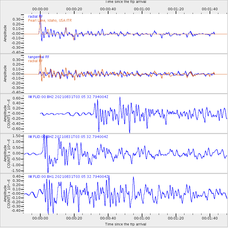
Signal To Noise
| Channel | StoN | STA | LTA |
| IW:PLID:00:BHZ:20210831T03:05:32.794004Z | 18.664892 | 8.391958E-7 | 4.4961194E-8 |
| IW:PLID:00:BH1:20210831T03:05:32.794004Z | 6.430234 | 1.7814254E-7 | 2.7703896E-8 |
| IW:PLID:00:BH2:20210831T03:05:32.794004Z | 8.616883 | 2.7551394E-7 | 3.1973734E-8 |
| Arrivals |
| Ps | 3.3 SECOND |
| PpPs | 11 SECOND |
| PsPs/PpSs | 14 SECOND |


