You are here: Home > Network List > N4 - Central and EAstern US Network Stations List
> Station MSTX Muleshoe, TX, USA > Earthquake Result Viewer
MSTX Muleshoe, TX, USA - Earthquake Result Viewer
| Earthquake location: |
Kermadec Islands, New Zealand |
| Earthquake latitude/longitude: |
-30.0/-177.5 |
| Earthquake time(UTC): |
2021/08/31 (243) 02:52:49 GMT |
| Earthquake Depth: |
10 km |
| Earthquake Magnitude: |
6.3 mww |
| Earthquake Catalog/Contributor: |
NEIC PDE/us |
|
| Network: |
N4 Central and EAstern US Network |
| Station: |
MSTX Muleshoe, TX, USA |
| Lat/Lon: |
33.97 N/102.77 W |
| Elevation: |
1167 m |
|
| Distance: |
95.0 deg |
| Az: |
53.59 deg |
| Baz: |
237.181 deg |
| Ray Param: |
0.04091544 |
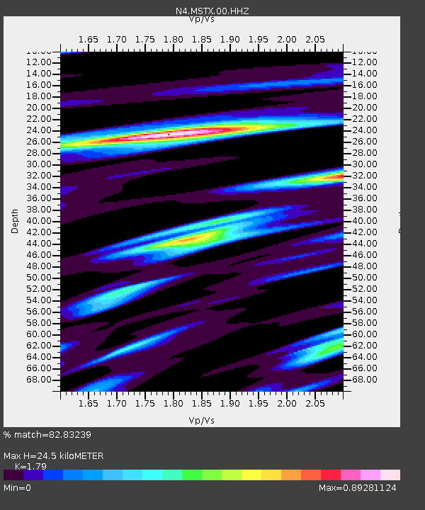
| Estimated Moho Depth: |
24.5 km |
| Estimated Crust Vp/Vs: |
1.79 |
| Assumed Crust Vp: |
6.129 km/s |
| Estimated Crust Vs: |
3.424 km/s |
| Estimated Crust Poisson's Ratio: |
0.27 |
|
| Radial Match: |
82.83239 % |
| Radial Bump: |
400 |
| Transverse Match: |
61.798973 % |
| Transverse Bump: |
400 |
| SOD ConfigId: |
25131211 |
| Insert Time: |
2021-09-14 03:24:10.510 +0000 |
| GWidth: |
2.5 |
| Max Bumps: |
400 |
| Tol: |
0.001 |
|

Signal To Noise
| Channel | StoN | STA | LTA |
| N4:MSTX:00:HHZ:20210831T03:05:40.400022Z | 3.620305 | 3.0991686E-7 | 8.560517E-8 |
| N4:MSTX:00:HH1:20210831T03:05:40.400022Z | 1.3568735 | 1.1616897E-7 | 8.561518E-8 |
| N4:MSTX:00:HH2:20210831T03:05:40.400022Z | 1.91597 | 1.661185E-7 | 8.670204E-8 |
| Arrivals |
| Ps | 3.2 SECOND |
| PpPs | 11 SECOND |
| PsPs/PpSs | 14 SECOND |


