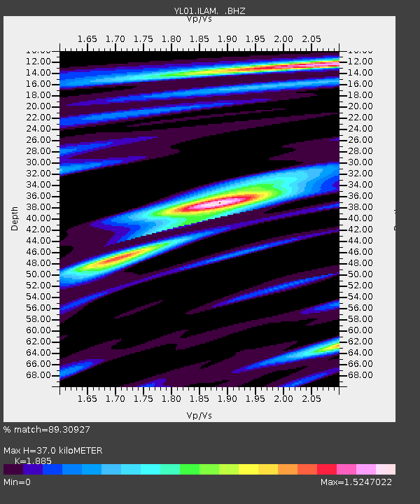
ILAM YL.ILAM - Earthquake Result Viewer
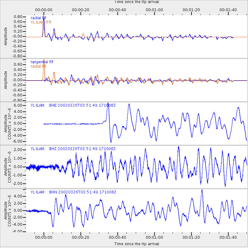
Earthquake location: Southwestern Ryukyu Isl., Japan
Earthquake latitude/longitude: 23.3/124.1
Earthquake time(UTC): 2002/03/26 (085) 03:45:48 GMT
Earthquake Depth: 33 km
Earthquake Magnitude: 5.8 MB, 6.6 MS, 6.4 MW, 6.4 MW
Earthquake Catalog/Contributor: WHDF/NEIC
Network: YL Himalayan Nepal Tibet Experiment
Station: ILAM YL.ILAM
Lat/Lon: 26.91 N/87.92 E
Elevation: 1181 m
Distance: 32.9 deg
Az: 283.828 deg
Baz: 88.117 deg
Ray Param: 0.0784176
Estimated Moho Depth: 37.0 km
Estimated Crust Vp/Vs: 1.88
Assumed Crust Vp: 6.236 km/s
Estimated Crust Vs: 3.308 km/s
Estimated Crust Poisson's Ratio: 0.30
Radial Match: 89.30927 %
Radial Bump: 336
Transverse Match: 84.24085 %
Transverse Bump: 400
SOD ConfigId: 16820
Insert Time: 2010-02-26 15:56:00.217 +0000
GWidth: 2.5
Max Bumps: 400
Tol: 0.001

Signal To Noise

ChannelStoNSTALTA
YL:ILAM: :BHZ:20020326T03:51:49.171008Z0.9764181.4094417E-71.4434818E-7
YL:ILAM: :BHN:20020326T03:51:49.171008Z10.1539351.221499E-61.202981E-7
YL:ILAM: :BHE:20020326T03:51:49.171008Z42.6987532.214495E-65.1863225E-8
Arrivals
Ps5.6 SECOND
PpPs16 SECOND
PsPs/PpSs22 SECOND