You are here: Home > Network List > YL01 - Himalayan Nepal Tibet Experiment Stations List
> Station ILAM YL.ILAM > Earthquake Result Viewer
ILAM YL.ILAM - Earthquake Result Viewer
| Earthquake location: |
Banda Sea |
| Earthquake latitude/longitude: |
-6.5/129.9 |
| Earthquake time(UTC): |
2002/03/19 (078) 22:14:14 GMT |
| Earthquake Depth: |
148 km |
| Earthquake Magnitude: |
5.7 MB, 6.1 MW, 6.0 MW |
| Earthquake Catalog/Contributor: |
WHDF/NEIC |
|
| Network: |
YL Himalayan Nepal Tibet Experiment |
| Station: |
ILAM YL.ILAM |
| Lat/Lon: |
26.91 N/87.92 E |
| Elevation: |
1181 m |
|
| Distance: |
52.5 deg |
| Az: |
311.145 deg |
| Baz: |
123.069 deg |
| Ray Param: |
0.06623098 |
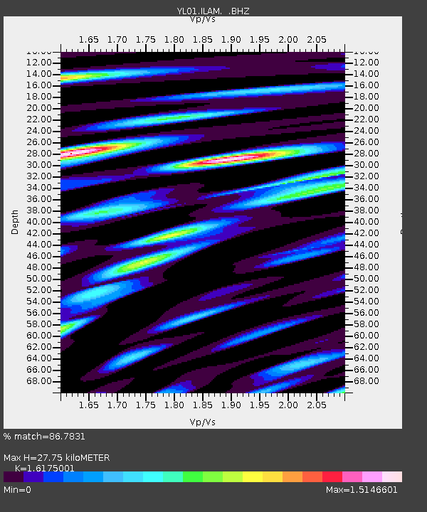
| Estimated Moho Depth: |
27.75 km |
| Estimated Crust Vp/Vs: |
1.62 |
| Assumed Crust Vp: |
6.236 km/s |
| Estimated Crust Vs: |
3.855 km/s |
| Estimated Crust Poisson's Ratio: |
0.19 |
|
| Radial Match: |
86.7831 % |
| Radial Bump: |
400 |
| Transverse Match: |
86.09185 % |
| Transverse Bump: |
400 |
| SOD ConfigId: |
16820 |
| Insert Time: |
2010-02-26 15:56:01.715 +0000 |
| GWidth: |
2.5 |
| Max Bumps: |
400 |
| Tol: |
0.001 |
|
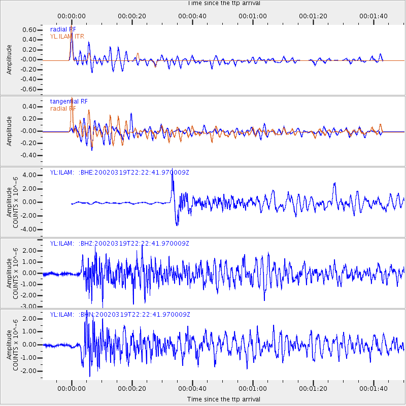
Signal To Noise
| Channel | StoN | STA | LTA |
| YL:ILAM: :BHZ:20020319T22:22:41.970009Z | 5.071066 | 4.464963E-7 | 8.804783E-8 |
| YL:ILAM: :BHN:20020319T22:22:41.970009Z | 11.135382 | 6.688396E-7 | 6.0064366E-8 |
| YL:ILAM: :BHE:20020319T22:22:41.970009Z | 18.452824 | 1.5306462E-6 | 8.294916E-8 |
| Arrivals |
| Ps | 2.9 SECOND |
| PpPs | 11 SECOND |
| PsPs/PpSs | 14 SECOND |


