You are here: Home > Network List > PF - Volcanologic Network of Piton de Fournaise-OVPF Stations List
> Station HIM cratere Himiltrude > Earthquake Result Viewer
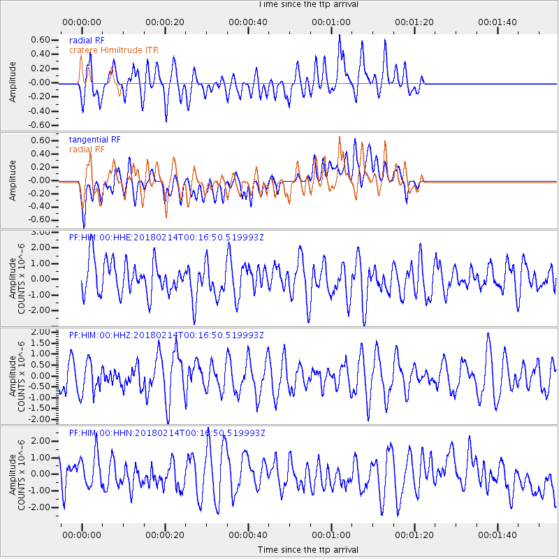
HIM cratere Himiltrude - Earthquake Result Viewer
*The percent match for this event was below the threshold and hence no stack was calculated.
| Earthquake location: |
Aru Islands Region, Indonesia |
| Earthquake latitude/longitude: |
-6.0/133.8 |
| Earthquake time(UTC): |
2018/02/14 (045) 00:05:30 GMT |
| Earthquake Depth: |
10 km |
| Earthquake Magnitude: |
5.5 mb |
| Earthquake Catalog/Contributor: |
NEIC PDE/us |
|
| Network: |
PF Volcanologic Network of Piton de Fournaise-OVPF |
| Station: |
HIM cratere Himiltrude |
| Lat/Lon: |
21.21 S/55.72 E |
| Elevation: |
1958 m |
|
| Distance: |
76.8 deg |
| Az: |
249.698 deg |
| Baz: |
91.353 deg |
| Ray Param: |
$rayparam |
*The percent match for this event was below the threshold and hence was not used in the summary stack. |
|
| Radial Match: |
70.38885 % |
| Radial Bump: |
400 |
| Transverse Match: |
48.826492 % |
| Transverse Bump: |
400 |
| SOD ConfigId: |
2546091 |
| Insert Time: |
2018-02-28 00:17:21.821 +0000 |
| GWidth: |
2.5 |
| Max Bumps: |
400 |
| Tol: |
0.001 |
|
Signal To Noise
| Channel | StoN | STA | LTA |
| PF:HIM:00:HHZ:20180214T00:16:50.519993Z | 0.9566378 | 7.3811145E-7 | 7.7156835E-7 |
| PF:HIM:00:HHN:20180214T00:16:50.519993Z | 1.0897025 | 1.3255582E-6 | 1.2164404E-6 |
| PF:HIM:00:HHE:20180214T00:16:50.519993Z | 0.96842796 | 9.850885E-7 | 1.0172037E-6 |
| Arrivals |
| Ps | |
| PpPs | |
| PsPs/PpSs | |


