You are here: Home > Network List > UO - University of Oregon Regional Network Stations List
> Station CAVE Cave Junction, OR, USA > Earthquake Result Viewer
CAVE Cave Junction, OR, USA - Earthquake Result Viewer
| Earthquake location: |
Kermadec Islands, New Zealand |
| Earthquake latitude/longitude: |
-30.0/-177.5 |
| Earthquake time(UTC): |
2021/08/31 (243) 02:52:49 GMT |
| Earthquake Depth: |
10 km |
| Earthquake Magnitude: |
6.3 mww |
| Earthquake Catalog/Contributor: |
NEIC PDE/us |
|
| Network: |
UO University of Oregon Regional Network |
| Station: |
CAVE Cave Junction, OR, USA |
| Lat/Lon: |
42.12 N/123.57 W |
| Elevation: |
440 m |
|
| Distance: |
87.2 deg |
| Az: |
37.024 deg |
| Baz: |
224.62 deg |
| Ray Param: |
0.043459356 |
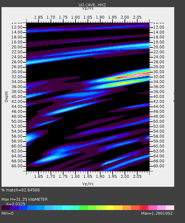
| Estimated Moho Depth: |
31.25 km |
| Estimated Crust Vp/Vs: |
2.03 |
| Assumed Crust Vp: |
6.522 km/s |
| Estimated Crust Vs: |
3.209 km/s |
| Estimated Crust Poisson's Ratio: |
0.34 |
|
| Radial Match: |
82.64588 % |
| Radial Bump: |
400 |
| Transverse Match: |
59.86686 % |
| Transverse Bump: |
400 |
| SOD ConfigId: |
25131211 |
| Insert Time: |
2021-09-14 03:28:22.953 +0000 |
| GWidth: |
2.5 |
| Max Bumps: |
400 |
| Tol: |
0.001 |
|

Signal To Noise
| Channel | StoN | STA | LTA |
| UO:CAVE: :HHZ:20210831T03:05:04.60803Z | 5.6533413 | 1.0209767E-6 | 1.8059704E-7 |
| UO:CAVE: :HHN:20210831T03:05:04.60803Z | 1.47968 | 2.5467995E-7 | 1.7211826E-7 |
| UO:CAVE: :HHE:20210831T03:05:04.60803Z | 2.2806673 | 4.0303834E-7 | 1.7671948E-7 |
| Arrivals |
| Ps | 5.0 SECOND |
| PpPs | 14 SECOND |
| PsPs/PpSs | 19 SECOND |


