You are here: Home > Network List > UU - University of Utah Regional Network Stations List
> Station FOR1 Milford Southwest, UT, USA > Earthquake Result Viewer
FOR1 Milford Southwest, UT, USA - Earthquake Result Viewer
| Earthquake location: |
Kermadec Islands, New Zealand |
| Earthquake latitude/longitude: |
-30.0/-177.5 |
| Earthquake time(UTC): |
2021/08/31 (243) 02:52:49 GMT |
| Earthquake Depth: |
10 km |
| Earthquake Magnitude: |
6.3 mww |
| Earthquake Catalog/Contributor: |
NEIC PDE/us |
|
| Network: |
UU University of Utah Regional Network |
| Station: |
FOR1 Milford Southwest, UT, USA |
| Lat/Lon: |
38.37 N/113.09 W |
| Elevation: |
1642 m |
|
| Distance: |
90.7 deg |
| Az: |
45.159 deg |
| Baz: |
231.521 deg |
| Ray Param: |
0.04168239 |
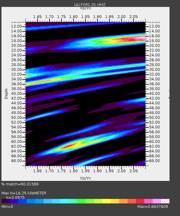
| Estimated Moho Depth: |
16.25 km |
| Estimated Crust Vp/Vs: |
2.10 |
| Assumed Crust Vp: |
6.276 km/s |
| Estimated Crust Vs: |
2.992 km/s |
| Estimated Crust Poisson's Ratio: |
0.35 |
|
| Radial Match: |
90.01599 % |
| Radial Bump: |
400 |
| Transverse Match: |
71.2889 % |
| Transverse Bump: |
400 |
| SOD ConfigId: |
25131211 |
| Insert Time: |
2021-09-14 03:29:55.408 +0000 |
| GWidth: |
2.5 |
| Max Bumps: |
400 |
| Tol: |
0.001 |
|

Signal To Noise
| Channel | StoN | STA | LTA |
| UU:FOR1:01:HHZ:20210831T03:05:20.92999Z | 12.328414 | 1.8604005E-8 | 1.5090348E-9 |
| UU:FOR1:01:HHN:20210831T03:05:20.92999Z | 1.5742813 | 3.736374E-9 | 2.3733837E-9 |
| UU:FOR1:01:HHE:20210831T03:05:20.92999Z | 2.9290693 | 5.572237E-9 | 1.9023918E-9 |
| Arrivals |
| Ps | 2.9 SECOND |
| PpPs | 7.9 SECOND |
| PsPs/PpSs | 11 SECOND |


