You are here: Home > Network List > UU - University of Utah Regional Network Stations List
> Station LIUT Lila Canyon, UT, USA > Earthquake Result Viewer
LIUT Lila Canyon, UT, USA - Earthquake Result Viewer
| Earthquake location: |
Kermadec Islands, New Zealand |
| Earthquake latitude/longitude: |
-30.0/-177.5 |
| Earthquake time(UTC): |
2021/08/31 (243) 02:52:49 GMT |
| Earthquake Depth: |
10 km |
| Earthquake Magnitude: |
6.3 mww |
| Earthquake Catalog/Contributor: |
NEIC PDE/us |
|
| Network: |
UU University of Utah Regional Network |
| Station: |
LIUT Lila Canyon, UT, USA |
| Lat/Lon: |
39.42 N/110.33 W |
| Elevation: |
2178 m |
|
| Distance: |
93.1 deg |
| Az: |
45.644 deg |
| Baz: |
233.236 deg |
| Ray Param: |
0.04134087 |
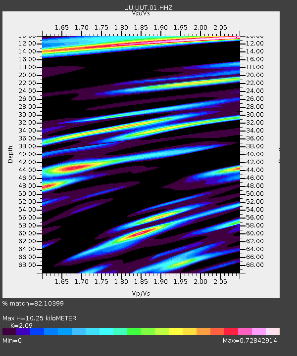
| Estimated Moho Depth: |
10.25 km |
| Estimated Crust Vp/Vs: |
2.09 |
| Assumed Crust Vp: |
6.207 km/s |
| Estimated Crust Vs: |
2.97 km/s |
| Estimated Crust Poisson's Ratio: |
0.35 |
|
| Radial Match: |
82.10399 % |
| Radial Bump: |
400 |
| Transverse Match: |
76.9897 % |
| Transverse Bump: |
400 |
| SOD ConfigId: |
25131211 |
| Insert Time: |
2021-09-14 03:30:07.742 +0000 |
| GWidth: |
2.5 |
| Max Bumps: |
400 |
| Tol: |
0.001 |
|

Signal To Noise
| Channel | StoN | STA | LTA |
| UU:LIUT:01:HHZ:20210831T03:05:31.780027Z | 6.923804 | 1.5847695E-8 | 2.288871E-9 |
| UU:LIUT:01:HHN:20210831T03:05:31.780027Z | 1.353349 | 4.619745E-9 | 3.413565E-9 |
| UU:LIUT:01:HHE:20210831T03:05:31.780027Z | 1.5599415 | 3.8325987E-9 | 2.456886E-9 |
| Arrivals |
| Ps | 1.8 SECOND |
| PpPs | 5.0 SECOND |
| PsPs/PpSs | 6.9 SECOND |


