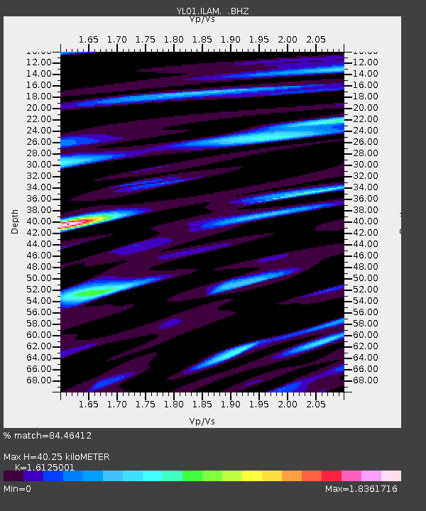
ILAM YL.ILAM - Earthquake Result Viewer
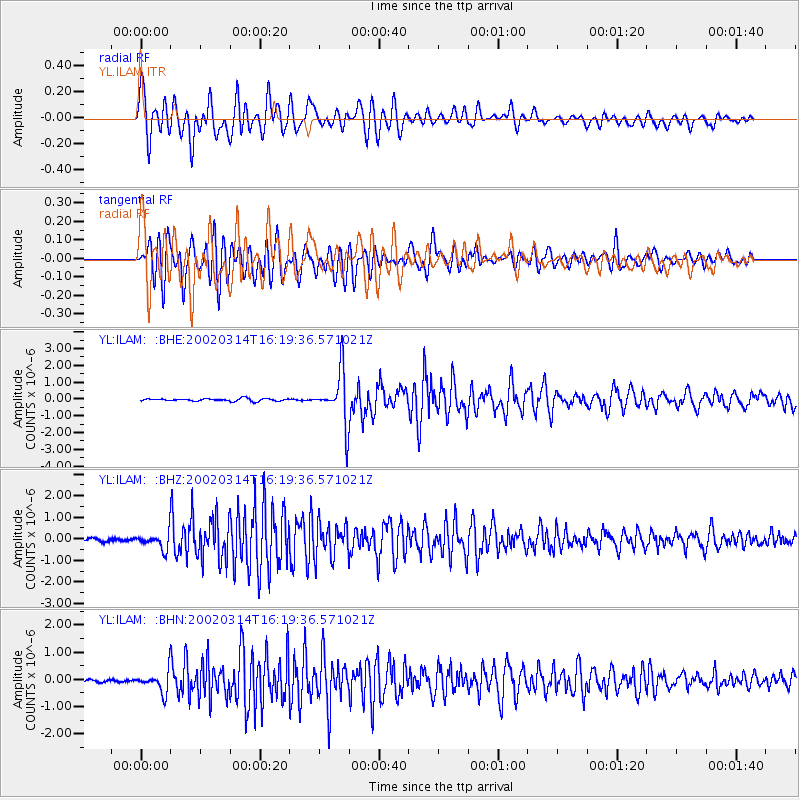
Earthquake location: Andreanof Islands, Aleutian Is.
Earthquake latitude/longitude: 51.5/-173.1
Earthquake time(UTC): 2002/03/14 (073) 16:08:31 GMT
Earthquake Depth: 33 km
Earthquake Magnitude: 5.5 MB, 5.4 MS, 5.9 MW, 5.6 MW
Earthquake Catalog/Contributor: WHDF/NEIC
Network: YL Himalayan Nepal Tibet Experiment
Station: ILAM YL.ILAM
Lat/Lon: 26.91 N/87.92 E
Elevation: 1181 m
Distance: 74.7 deg
Az: 293.867 deg
Baz: 39.771 deg
Ray Param: 0.052128423
Estimated Moho Depth: 40.25 km
Estimated Crust Vp/Vs: 1.61
Assumed Crust Vp: 6.236 km/s
Estimated Crust Vs: 3.867 km/s
Estimated Crust Poisson's Ratio: 0.19
Radial Match: 84.46412 %
Radial Bump: 400
Transverse Match: 86.57099 %
Transverse Bump: 400
SOD ConfigId: 16820
Insert Time: 2010-02-26 15:56:04.782 +0000
GWidth: 2.5
Max Bumps: 400
Tol: 0.001

Signal To Noise

ChannelStoNSTALTA
YL:ILAM: :BHZ:20020314T16:19:36.571021Z6.21667863.6358531E-75.848546E-8
YL:ILAM: :BHN:20020314T16:19:36.571021Z8.973573.8305896E-74.2687464E-8
YL:ILAM: :BHE:20020314T16:19:36.571021Z20.5401211.5411964E-67.503346E-8
Arrivals
Ps4.1 SECOND
PpPs16 SECOND
PsPs/PpSs20 SECOND