You are here: Home > Network List > WY - Yellowstone Wyoming Seismic Network Stations List
> Station YHB Horse Butte YNP, MT, USA > Earthquake Result Viewer
YHB Horse Butte YNP, MT, USA - Earthquake Result Viewer
| Earthquake location: |
Kermadec Islands, New Zealand |
| Earthquake latitude/longitude: |
-30.0/-177.5 |
| Earthquake time(UTC): |
2021/08/31 (243) 02:52:49 GMT |
| Earthquake Depth: |
10 km |
| Earthquake Magnitude: |
6.3 mww |
| Earthquake Catalog/Contributor: |
NEIC PDE/us |
|
| Network: |
WY Yellowstone Wyoming Seismic Network |
| Station: |
YHB Horse Butte YNP, MT, USA |
| Lat/Lon: |
44.75 N/111.20 W |
| Elevation: |
2167 m |
|
| Distance: |
95.8 deg |
| Az: |
40.983 deg |
| Baz: |
233.013 deg |
| Ray Param: |
0.040708125 |
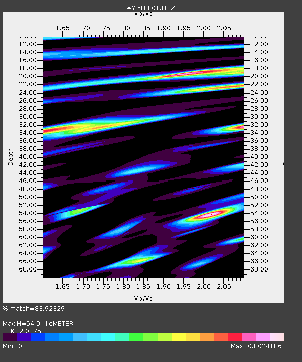
| Estimated Moho Depth: |
54.0 km |
| Estimated Crust Vp/Vs: |
2.02 |
| Assumed Crust Vp: |
6.35 km/s |
| Estimated Crust Vs: |
3.147 km/s |
| Estimated Crust Poisson's Ratio: |
0.34 |
|
| Radial Match: |
83.92329 % |
| Radial Bump: |
400 |
| Transverse Match: |
60.571632 % |
| Transverse Bump: |
400 |
| SOD ConfigId: |
25131211 |
| Insert Time: |
2021-09-14 03:32:46.110 +0000 |
| GWidth: |
2.5 |
| Max Bumps: |
400 |
| Tol: |
0.001 |
|

Signal To Noise
| Channel | StoN | STA | LTA |
| WY:YHB:01:HHZ:20210831T03:05:43.970029Z | 6.445898 | 8.510695E-9 | 1.3203273E-9 |
| WY:YHB:01:HHN:20210831T03:05:43.970029Z | 1.458569 | 1.5199696E-9 | 1.0420964E-9 |
| WY:YHB:01:HHE:20210831T03:05:43.970029Z | 3.1938355 | 4.253459E-9 | 1.3317715E-9 |
| Arrivals |
| Ps | 8.8 SECOND |
| PpPs | 25 SECOND |
| PsPs/PpSs | 34 SECOND |


