You are here: Home > Network List > WY - Yellowstone Wyoming Seismic Network Stations List
> Station YHH Holmes Hill, YNP, WY, USA > Earthquake Result Viewer
YHH Holmes Hill, YNP, WY, USA - Earthquake Result Viewer
| Earthquake location: |
Kermadec Islands, New Zealand |
| Earthquake latitude/longitude: |
-30.0/-177.5 |
| Earthquake time(UTC): |
2021/08/31 (243) 02:52:49 GMT |
| Earthquake Depth: |
10 km |
| Earthquake Magnitude: |
6.3 mww |
| Earthquake Catalog/Contributor: |
NEIC PDE/us |
|
| Network: |
WY Yellowstone Wyoming Seismic Network |
| Station: |
YHH Holmes Hill, YNP, WY, USA |
| Lat/Lon: |
44.79 N/110.85 W |
| Elevation: |
2717 m |
|
| Distance: |
96.0 deg |
| Az: |
41.102 deg |
| Baz: |
233.244 deg |
| Ray Param: |
0.04064768 |
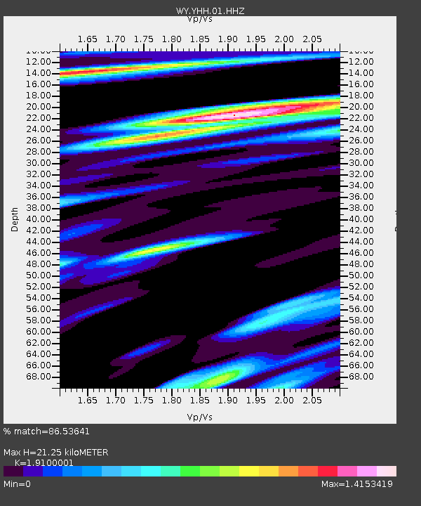
| Estimated Moho Depth: |
21.25 km |
| Estimated Crust Vp/Vs: |
1.91 |
| Assumed Crust Vp: |
6.35 km/s |
| Estimated Crust Vs: |
3.325 km/s |
| Estimated Crust Poisson's Ratio: |
0.31 |
|
| Radial Match: |
86.53641 % |
| Radial Bump: |
400 |
| Transverse Match: |
78.031715 % |
| Transverse Bump: |
400 |
| SOD ConfigId: |
25131211 |
| Insert Time: |
2021-09-14 03:32:48.469 +0000 |
| GWidth: |
2.5 |
| Max Bumps: |
400 |
| Tol: |
0.001 |
|
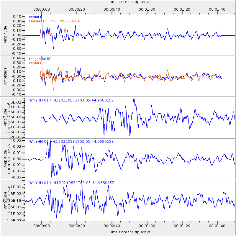
Signal To Noise
| Channel | StoN | STA | LTA |
| WY:YHH:01:HHZ:20210831T03:05:44.968015Z | 9.359799 | 1.1851318E-8 | 1.2661937E-9 |
| WY:YHH:01:HHN:20210831T03:05:44.968015Z | 1.6409925 | 3.1619538E-9 | 1.9268545E-9 |
| WY:YHH:01:HHE:20210831T03:05:44.968015Z | 2.1258018 | 4.821413E-9 | 2.2680444E-9 |
| Arrivals |
| Ps | 3.1 SECOND |
| PpPs | 9.6 SECOND |
| PsPs/PpSs | 13 SECOND |


