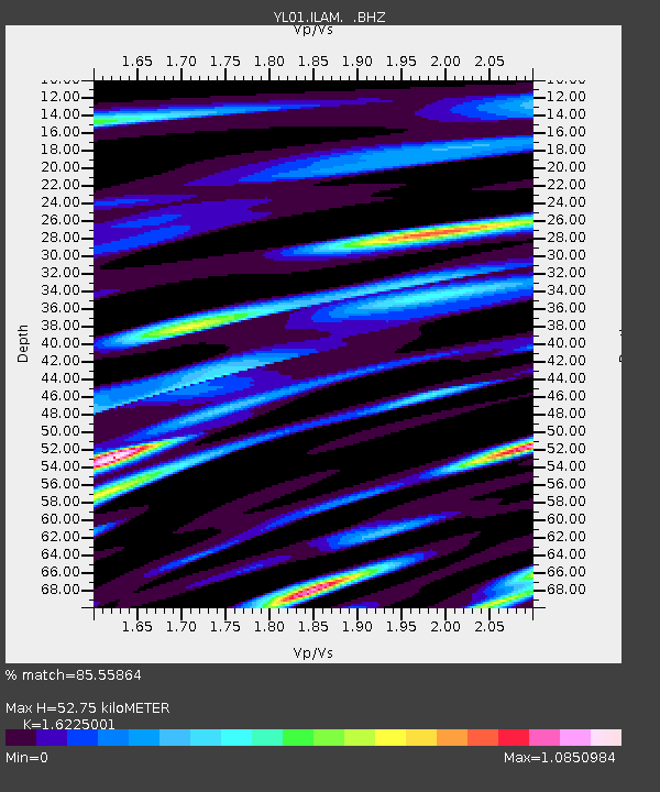
ILAM YL.ILAM - Earthquake Result Viewer
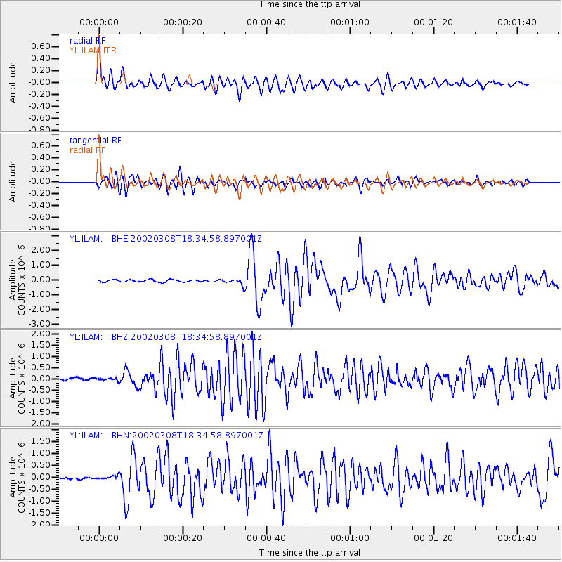
Earthquake location: Mindanao, Philippines
Earthquake latitude/longitude: 5.9/124.3
Earthquake time(UTC): 2002/03/08 (067) 18:27:53 GMT
Earthquake Depth: 23 km
Earthquake Magnitude: 5.6 MB, 5.7 MS, 6.0 MW, 5.8 MW
Earthquake Catalog/Contributor: WHDF/NEIC
Network: YL Himalayan Nepal Tibet Experiment
Station: ILAM YL.ILAM
Lat/Lon: 26.91 N/87.92 E
Elevation: 1181 m
Distance: 40.4 deg
Az: 305.302 deg
Baz: 114.599 deg
Ray Param: 0.07437164
Estimated Moho Depth: 52.75 km
Estimated Crust Vp/Vs: 1.62
Assumed Crust Vp: 6.236 km/s
Estimated Crust Vs: 3.843 km/s
Estimated Crust Poisson's Ratio: 0.19
Radial Match: 85.55864 %
Radial Bump: 400
Transverse Match: 77.808014 %
Transverse Bump: 400
SOD ConfigId: 16820
Insert Time: 2010-02-26 15:56:07.290 +0000
GWidth: 2.5
Max Bumps: 400
Tol: 0.001

Signal To Noise

ChannelStoNSTALTA
YL:ILAM: :BHZ:20020308T18:34:58.897001Z1.07218815.8625666E-85.4678527E-8
YL:ILAM: :BHN:20020308T18:34:58.897001Z1.46421658.039914E-85.4909325E-8
YL:ILAM: :BHE:20020308T18:34:58.897001Z2.81278062.1816923E-77.756355E-8
Arrivals
Ps5.7 SECOND
PpPs21 SECOND
PsPs/PpSs26 SECOND