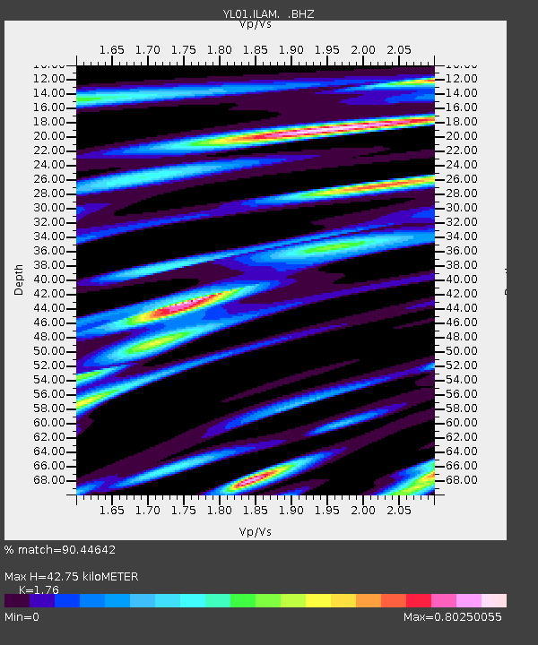
ILAM YL.ILAM - Earthquake Result Viewer
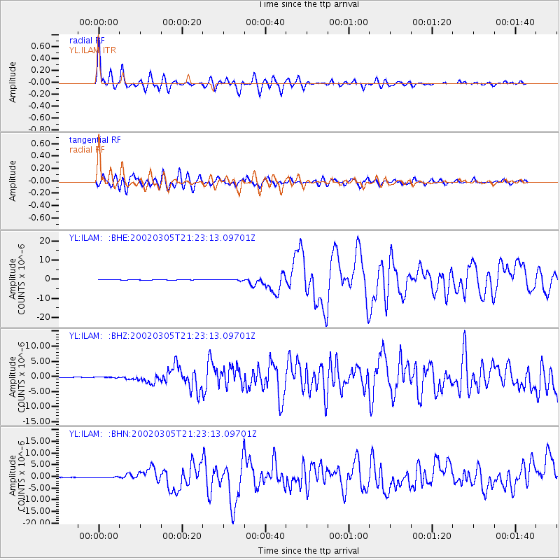
Earthquake location: Mindanao, Philippines
Earthquake latitude/longitude: 6.0/124.2
Earthquake time(UTC): 2002/03/05 (064) 21:16:09 GMT
Earthquake Depth: 31 km
Earthquake Magnitude: 6.3 MB, 7.2 MS, 7.5 MW, 7.2 MW
Earthquake Catalog/Contributor: WHDF/NEIC
Network: YL Himalayan Nepal Tibet Experiment
Station: ILAM YL.ILAM
Lat/Lon: 26.91 N/87.92 E
Elevation: 1181 m
Distance: 40.3 deg
Az: 305.162 deg
Baz: 114.419 deg
Ray Param: 0.07441468
Estimated Moho Depth: 42.75 km
Estimated Crust Vp/Vs: 1.76
Assumed Crust Vp: 6.236 km/s
Estimated Crust Vs: 3.543 km/s
Estimated Crust Poisson's Ratio: 0.26
Radial Match: 90.44642 %
Radial Bump: 400
Transverse Match: 84.81896 %
Transverse Bump: 400
SOD ConfigId: 16820
Insert Time: 2010-02-26 15:56:08.665 +0000
GWidth: 2.5
Max Bumps: 400
Tol: 0.001

Signal To Noise

ChannelStoNSTALTA
YL:ILAM: :BHZ:20020305T21:23:13.09701Z1.94509631.3610018E-76.997093E-8
YL:ILAM: :BHN:20020305T21:23:13.09701Z2.0127881.9636282E-79.7557624E-8
YL:ILAM: :BHE:20020305T21:23:13.09701Z2.52944092.7659584E-71.09350594E-7
Arrivals
Ps5.6 SECOND
PpPs18 SECOND
PsPs/PpSs23 SECOND