You are here: Home > Network List > CU - Caribbean Network (USGS) Stations List
> Station BBGH Gun Hill, Barbados > Earthquake Result Viewer
BBGH Gun Hill, Barbados - Earthquake Result Viewer
| Earthquake location: |
Oaxaca, Mexico |
| Earthquake latitude/longitude: |
16.4/-97.9 |
| Earthquake time(UTC): |
2018/02/16 (047) 23:39:44 GMT |
| Earthquake Depth: |
43 km |
| Earthquake Magnitude: |
7.5 Mi |
| Earthquake Catalog/Contributor: |
NEIC PDE/at |
|
| Network: |
CU Caribbean Network (USGS) |
| Station: |
BBGH Gun Hill, Barbados |
| Lat/Lon: |
13.14 N/59.56 W |
| Elevation: |
180 m |
|
| Distance: |
37.2 deg |
| Az: |
89.765 deg |
| Baz: |
279.838 deg |
| Ray Param: |
0.07617958 |
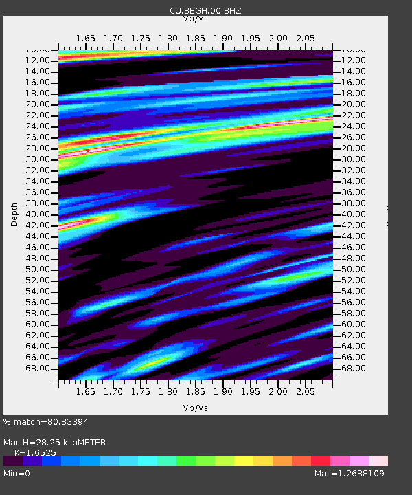
| Estimated Moho Depth: |
28.25 km |
| Estimated Crust Vp/Vs: |
1.65 |
| Assumed Crust Vp: |
4.438 km/s |
| Estimated Crust Vs: |
2.686 km/s |
| Estimated Crust Poisson's Ratio: |
0.21 |
|
| Radial Match: |
80.83394 % |
| Radial Bump: |
400 |
| Transverse Match: |
59.82576 % |
| Transverse Bump: |
400 |
| SOD ConfigId: |
2546091 |
| Insert Time: |
2018-03-02 23:41:06.488 +0000 |
| GWidth: |
2.5 |
| Max Bumps: |
400 |
| Tol: |
0.001 |
|
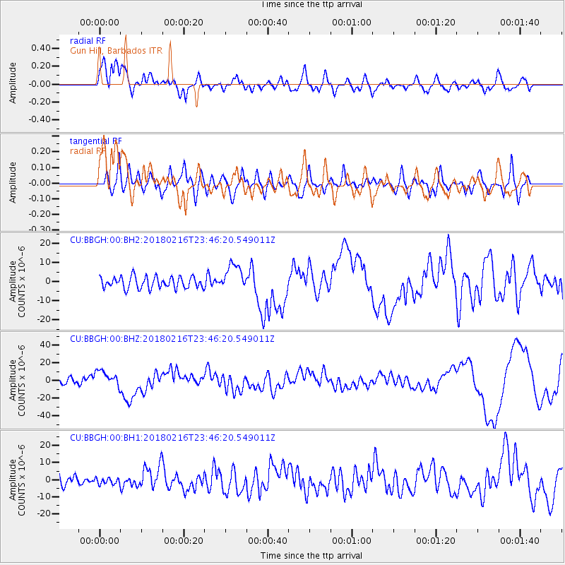
Signal To Noise
| Channel | StoN | STA | LTA |
| CU:BBGH:00:BHZ:20180216T23:46:20.549011Z | 2.7112026 | 9.255609E-6 | 3.413839E-6 |
| CU:BBGH:00:BH1:20180216T23:46:20.549011Z | 0.6730949 | 1.8467483E-6 | 2.743667E-6 |
| CU:BBGH:00:BH2:20180216T23:46:20.549011Z | 2.3696067 | 7.134361E-6 | 3.0107785E-6 |
| Arrivals |
| Ps | 4.3 SECOND |
| PpPs | 16 SECOND |
| PsPs/PpSs | 21 SECOND |


