You are here: Home > Network List > G - GEOSCOPE Stations List
> Station MBO M'Bour, Senegal > Earthquake Result Viewer
MBO M'Bour, Senegal - Earthquake Result Viewer
| Earthquake location: |
Oaxaca, Mexico |
| Earthquake latitude/longitude: |
16.4/-97.9 |
| Earthquake time(UTC): |
2018/02/16 (047) 23:39:44 GMT |
| Earthquake Depth: |
43 km |
| Earthquake Magnitude: |
7.5 Mi |
| Earthquake Catalog/Contributor: |
NEIC PDE/at |
|
| Network: |
G GEOSCOPE |
| Station: |
MBO M'Bour, Senegal |
| Lat/Lon: |
14.39 N/16.95 W |
| Elevation: |
3.0 m |
|
| Distance: |
77.5 deg |
| Az: |
78.525 deg |
| Baz: |
283.902 deg |
| Ray Param: |
0.050177515 |
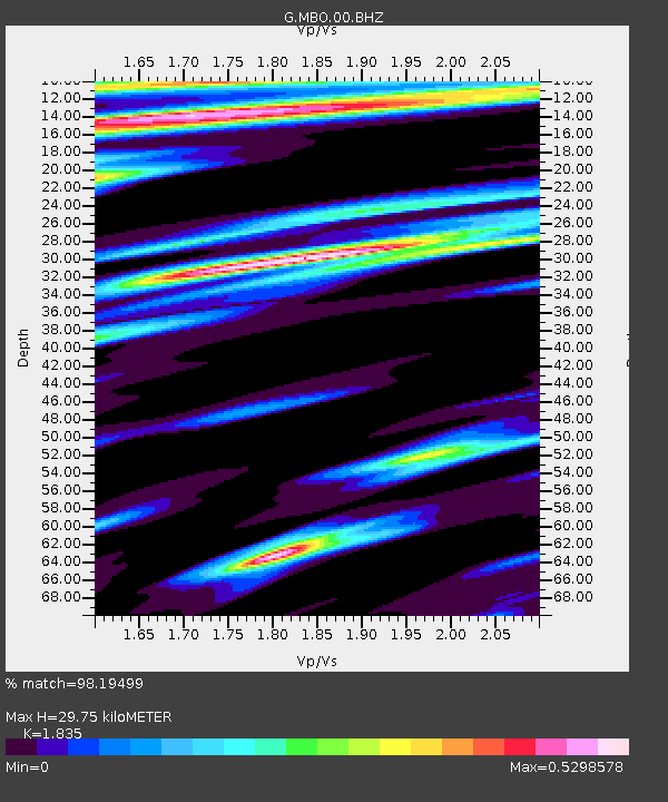
| Estimated Moho Depth: |
29.75 km |
| Estimated Crust Vp/Vs: |
1.84 |
| Assumed Crust Vp: |
5.55 km/s |
| Estimated Crust Vs: |
3.025 km/s |
| Estimated Crust Poisson's Ratio: |
0.29 |
|
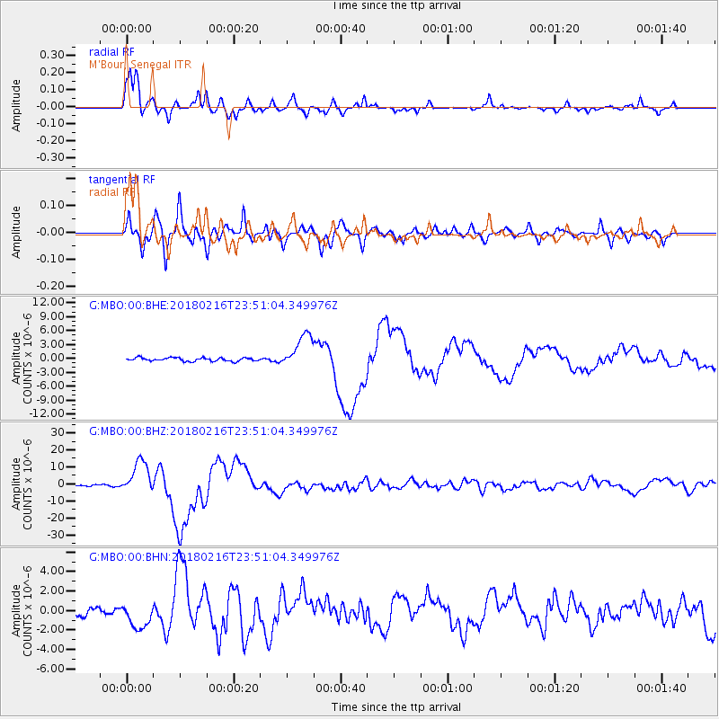
| Radial Match: |
98.19499 % |
| Radial Bump: |
356 |
| Transverse Match: |
91.46609 % |
| Transverse Bump: |
400 |
| SOD ConfigId: |
2546091 |
| Insert Time: |
2018-03-02 23:41:18.673 +0000 |
| GWidth: |
2.5 |
| Max Bumps: |
400 |
| Tol: |
0.001 |
|
Signal To Noise
| Channel | StoN | STA | LTA |
| G:MBO:00:BHZ:20180216T23:51:04.349976Z | 30.483753 | 9.886028E-6 | 3.2430484E-7 |
| G:MBO:00:BHN:20180216T23:51:04.349976Z | 3.8395991 | 1.3558733E-6 | 3.5312885E-7 |
| G:MBO:00:BHE:20180216T23:51:04.349976Z | 10.235716 | 3.7530908E-6 | 3.666662E-7 |
| Arrivals |
| Ps | 4.6 SECOND |
| PpPs | 15 SECOND |
| PsPs/PpSs | 19 SECOND |


