You are here: Home > Network List > AV - Alaska Volcano Observatory Stations List
> Station SPCR Ckakachatna River, Mount Spurr, Alaska > Earthquake Result Viewer
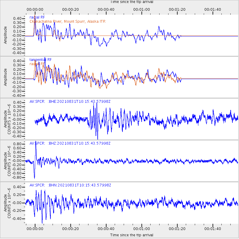
SPCR Ckakachatna River, Mount Spurr, Alaska - Earthquake Result Viewer
*The percent match for this event was below the threshold and hence no stack was calculated.
| Earthquake location: |
Fiji Islands Region |
| Earthquake latitude/longitude: |
-18.1/-178.2 |
| Earthquake time(UTC): |
2021/08/31 (243) 10:04:54 GMT |
| Earthquake Depth: |
559 km |
| Earthquake Magnitude: |
5.5 Mww |
| Earthquake Catalog/Contributor: |
NEIC PDE/us |
|
| Network: |
AV Alaska Volcano Observatory |
| Station: |
SPCR Ckakachatna River, Mount Spurr, Alaska |
| Lat/Lon: |
61.20 N/152.21 W |
| Elevation: |
984 m |
|
| Distance: |
81.8 deg |
| Az: |
12.389 deg |
| Baz: |
204.921 deg |
| Ray Param: |
$rayparam |
*The percent match for this event was below the threshold and hence was not used in the summary stack. |
|
| Radial Match: |
43.70913 % |
| Radial Bump: |
400 |
| Transverse Match: |
45.053177 % |
| Transverse Bump: |
400 |
| SOD ConfigId: |
25131211 |
| Insert Time: |
2021-09-14 10:13:19.532 +0000 |
| GWidth: |
2.5 |
| Max Bumps: |
400 |
| Tol: |
0.001 |
|
Signal To Noise
| Channel | StoN | STA | LTA |
| AV:SPCR: :BHZ:20210831T10:15:43.57998Z | 6.501617 | 3.3521076E-7 | 5.155806E-8 |
| AV:SPCR: :BHN:20210831T10:15:43.57998Z | 4.4157577 | 2.0005362E-7 | 4.5304482E-8 |
| AV:SPCR: :BHE:20210831T10:15:43.57998Z | 3.0117977 | 1.7159938E-7 | 5.6975733E-8 |
| Arrivals |
| Ps | |
| PpPs | |
| PsPs/PpSs | |


