You are here: Home > Network List > AZ - ANZA Regional Network Stations List
> Station SMER AZ.SMER > Earthquake Result Viewer
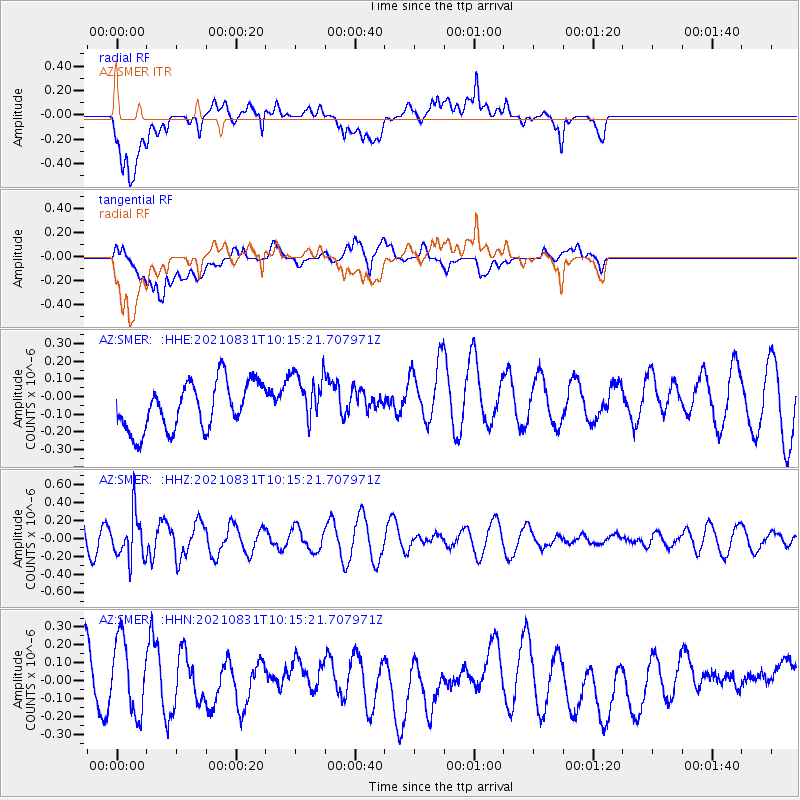
SMER AZ.SMER - Earthquake Result Viewer
*The percent match for this event was below the threshold and hence no stack was calculated.
| Earthquake location: |
Fiji Islands Region |
| Earthquake latitude/longitude: |
-18.1/-178.2 |
| Earthquake time(UTC): |
2021/08/31 (243) 10:04:54 GMT |
| Earthquake Depth: |
559 km |
| Earthquake Magnitude: |
5.5 Mww |
| Earthquake Catalog/Contributor: |
NEIC PDE/us |
|
| Network: |
AZ ANZA Regional Network |
| Station: |
SMER AZ.SMER |
| Lat/Lon: |
33.46 N/117.17 W |
| Elevation: |
355 m |
|
| Distance: |
77.6 deg |
| Az: |
48.509 deg |
| Baz: |
238.445 deg |
| Ray Param: |
$rayparam |
*The percent match for this event was below the threshold and hence was not used in the summary stack. |
|
| Radial Match: |
50.341885 % |
| Radial Bump: |
400 |
| Transverse Match: |
35.932262 % |
| Transverse Bump: |
400 |
| SOD ConfigId: |
25131211 |
| Insert Time: |
2021-09-14 10:13:56.196 +0000 |
| GWidth: |
2.5 |
| Max Bumps: |
400 |
| Tol: |
0.001 |
|
Signal To Noise
| Channel | StoN | STA | LTA |
| AZ:SMER: :HHZ:20210831T10:15:21.707971Z | 1.721286 | 2.5440963E-7 | 1.4780207E-7 |
| AZ:SMER: :HHN:20210831T10:15:21.707971Z | 1.0685241 | 2.0669678E-7 | 1.9344138E-7 |
| AZ:SMER: :HHE:20210831T10:15:21.707971Z | 1.1105318 | 1.4890148E-7 | 1.3408123E-7 |
| Arrivals |
| Ps | |
| PpPs | |
| PsPs/PpSs | |


