You are here: Home > Network List > CC - Cascade Chain Volcano Monitoring Stations List
> Station KAUT Kautz Creek Helibase > Earthquake Result Viewer
KAUT Kautz Creek Helibase - Earthquake Result Viewer
| Earthquake location: |
Fiji Islands Region |
| Earthquake latitude/longitude: |
-18.1/-178.2 |
| Earthquake time(UTC): |
2021/08/31 (243) 10:04:54 GMT |
| Earthquake Depth: |
559 km |
| Earthquake Magnitude: |
5.5 Mww |
| Earthquake Catalog/Contributor: |
NEIC PDE/us |
|
| Network: |
CC Cascade Chain Volcano Monitoring |
| Station: |
KAUT Kautz Creek Helibase |
| Lat/Lon: |
46.73 N/121.86 W |
| Elevation: |
689 m |
|
| Distance: |
82.1 deg |
| Az: |
35.325 deg |
| Baz: |
233.074 deg |
| Ray Param: |
0.04549619 |
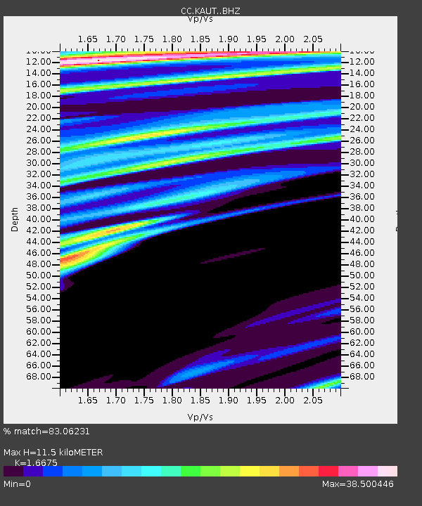
| Estimated Moho Depth: |
11.5 km |
| Estimated Crust Vp/Vs: |
1.67 |
| Assumed Crust Vp: |
6.597 km/s |
| Estimated Crust Vs: |
3.957 km/s |
| Estimated Crust Poisson's Ratio: |
0.22 |
|
| Radial Match: |
83.06231 % |
| Radial Bump: |
292 |
| Transverse Match: |
78.71707 % |
| Transverse Bump: |
400 |
| SOD ConfigId: |
25131211 |
| Insert Time: |
2021-09-14 10:15:31.108 +0000 |
| GWidth: |
2.5 |
| Max Bumps: |
400 |
| Tol: |
0.001 |
|

Signal To Noise
| Channel | StoN | STA | LTA |
| CC:KAUT: :BHZ:20210831T10:15:45.159997Z | 1.9336826 | 2.4324723E-7 | 1.2579481E-7 |
| CC:KAUT: :BHN:20210831T10:15:45.159997Z | 1.1176344 | 8.761411E-6 | 7.839245E-6 |
| CC:KAUT: :BHE:20210831T10:15:45.159997Z | 1.1891773 | 4.4297335E-6 | 3.7250406E-6 |
| Arrivals |
| Ps | 1.2 SECOND |
| PpPs | 4.5 SECOND |
| PsPs/PpSs | 5.7 SECOND |


