You are here: Home > Network List > IW - Intermountain West Stations List
> Station PLID Pearl Lake, Idaho, USA > Earthquake Result Viewer
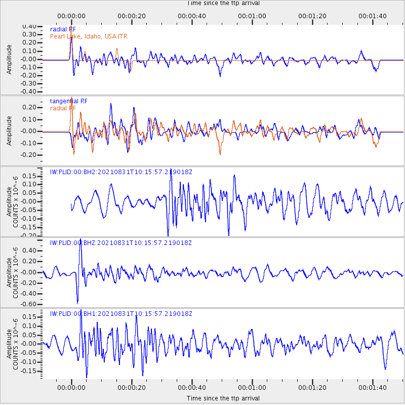
PLID Pearl Lake, Idaho, USA - Earthquake Result Viewer
*The percent match for this event was below the threshold and hence no stack was calculated.
| Earthquake location: |
Fiji Islands Region |
| Earthquake latitude/longitude: |
-18.1/-178.2 |
| Earthquake time(UTC): |
2021/08/31 (243) 10:04:54 GMT |
| Earthquake Depth: |
559 km |
| Earthquake Magnitude: |
5.5 Mww |
| Earthquake Catalog/Contributor: |
NEIC PDE/us |
|
| Network: |
IW Intermountain West |
| Station: |
PLID Pearl Lake, Idaho, USA |
| Lat/Lon: |
45.09 N/116.00 W |
| Elevation: |
2164 m |
|
| Distance: |
84.5 deg |
| Az: |
39.023 deg |
| Baz: |
237.702 deg |
| Ray Param: |
$rayparam |
*The percent match for this event was below the threshold and hence was not used in the summary stack. |
|
| Radial Match: |
69.09622 % |
| Radial Bump: |
400 |
| Transverse Match: |
60.94557 % |
| Transverse Bump: |
400 |
| SOD ConfigId: |
25131211 |
| Insert Time: |
2021-09-14 10:19:58.184 +0000 |
| GWidth: |
2.5 |
| Max Bumps: |
400 |
| Tol: |
0.001 |
|
Signal To Noise
| Channel | StoN | STA | LTA |
| IW:PLID:00:BHZ:20210831T10:15:57.219018Z | 4.3759537 | 2.6110754E-7 | 5.966872E-8 |
| IW:PLID:00:BH1:20210831T10:15:57.219018Z | 2.0418873 | 6.583053E-8 | 3.224004E-8 |
| IW:PLID:00:BH2:20210831T10:15:57.219018Z | 2.1776981 | 9.036163E-8 | 4.1494104E-8 |
| Arrivals |
| Ps | |
| PpPs | |
| PsPs/PpSs | |


