You are here: Home > Network List > YL01 - Himalayan Nepal Tibet Experiment Stations List
> Station ILAM YL.ILAM > Earthquake Result Viewer
ILAM YL.ILAM - Earthquake Result Viewer
| Earthquake location: |
New Britain Region, P.N.G. |
| Earthquake latitude/longitude: |
-4.5/152.0 |
| Earthquake time(UTC): |
2002/02/23 (054) 19:37:13 GMT |
| Earthquake Depth: |
155 km |
| Earthquake Magnitude: |
5.5 MB, 5.7 MW, 5.6 MW |
| Earthquake Catalog/Contributor: |
WHDF/NEIC |
|
| Network: |
YL Himalayan Nepal Tibet Experiment |
| Station: |
ILAM YL.ILAM |
| Lat/Lon: |
26.91 N/87.92 E |
| Elevation: |
1181 m |
|
| Distance: |
69.2 deg |
| Az: |
300.816 deg |
| Baz: |
106.479 deg |
| Ray Param: |
0.055362403 |
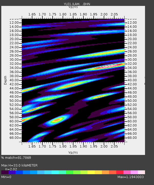
| Estimated Moho Depth: |
33.0 km |
| Estimated Crust Vp/Vs: |
2.02 |
| Assumed Crust Vp: |
6.236 km/s |
| Estimated Crust Vs: |
3.087 km/s |
| Estimated Crust Poisson's Ratio: |
0.34 |
|
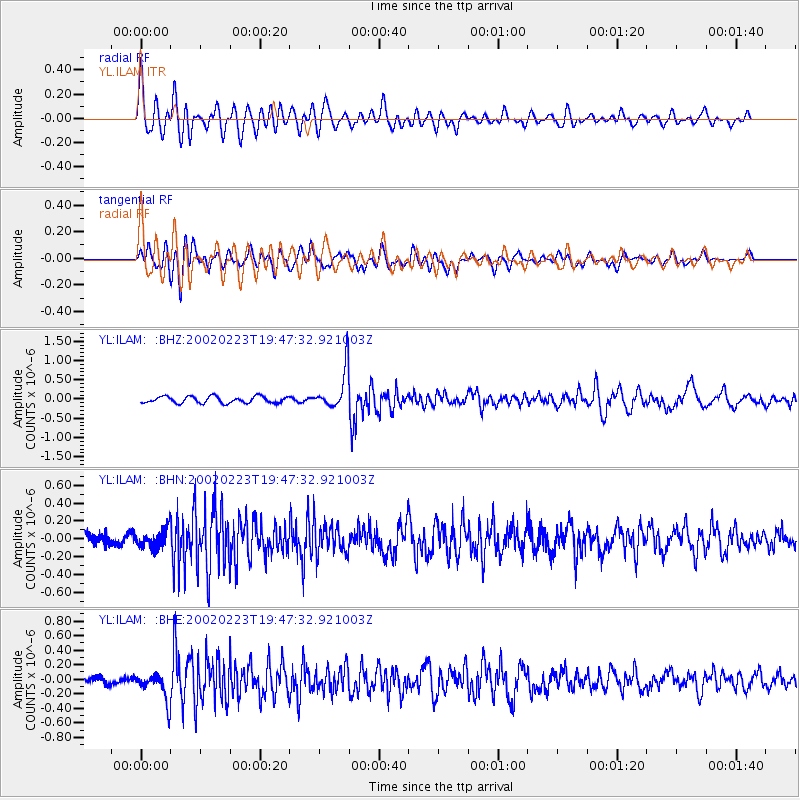
| Radial Match: |
81.7869 % |
| Radial Bump: |
400 |
| Transverse Match: |
74.73974 % |
| Transverse Bump: |
400 |
| SOD ConfigId: |
16820 |
| Insert Time: |
2010-02-26 15:56:12.005 +0000 |
| GWidth: |
2.5 |
| Max Bumps: |
400 |
| Tol: |
0.001 |
|
Signal To Noise
| Channel | StoN | STA | LTA |
| YL:ILAM: :BHN:20020223T19:47:32.921003Z | 1.9464253 | 1.009558E-7 | 5.1867286E-8 |
| YL:ILAM: :BHE:20020223T19:47:32.921003Z | 4.098758 | 1.8278332E-7 | 4.4594806E-8 |
| YL:ILAM: :BHZ:20020223T19:47:32.921003Z | 5.956915 | 5.099934E-7 | 8.5613685E-8 |
| Arrivals |
| Ps | 5.6 SECOND |
| PpPs | 15 SECOND |
| PsPs/PpSs | 21 SECOND |


