You are here: Home > Network List > UU - University of Utah Regional Network Stations List
> Station CCUT Cedar City, UT, USA > Earthquake Result Viewer
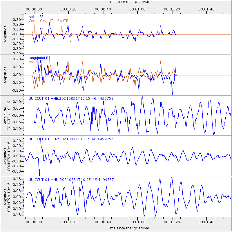
CCUT Cedar City, UT, USA - Earthquake Result Viewer
*The percent match for this event was below the threshold and hence no stack was calculated.
| Earthquake location: |
Fiji Islands Region |
| Earthquake latitude/longitude: |
-18.1/-178.2 |
| Earthquake time(UTC): |
2021/08/31 (243) 10:04:54 GMT |
| Earthquake Depth: |
559 km |
| Earthquake Magnitude: |
5.5 Mww |
| Earthquake Catalog/Contributor: |
NEIC PDE/us |
|
| Network: |
UU University of Utah Regional Network |
| Station: |
CCUT Cedar City, UT, USA |
| Lat/Lon: |
37.55 N/113.36 W |
| Elevation: |
2127 m |
|
| Distance: |
82.3 deg |
| Az: |
46.55 deg |
| Baz: |
240.306 deg |
| Ray Param: |
$rayparam |
*The percent match for this event was below the threshold and hence was not used in the summary stack. |
|
| Radial Match: |
57.99133 % |
| Radial Bump: |
334 |
| Transverse Match: |
61.804066 % |
| Transverse Bump: |
385 |
| SOD ConfigId: |
25131211 |
| Insert Time: |
2021-09-14 10:26:21.490 +0000 |
| GWidth: |
2.5 |
| Max Bumps: |
400 |
| Tol: |
0.001 |
|
Signal To Noise
| Channel | StoN | STA | LTA |
| UU:CCUT:01:HHZ:20210831T10:15:46.449975Z | 1.9272358 | 1.5210009E-7 | 7.892137E-8 |
| UU:CCUT:01:HHN:20210831T10:15:46.449975Z | 1.1863769 | 5.0705534E-8 | 4.2739817E-8 |
| UU:CCUT:01:HHE:20210831T10:15:46.449975Z | 1.1670041 | 5.4116093E-8 | 4.637181E-8 |
| Arrivals |
| Ps | |
| PpPs | |
| PsPs/PpSs | |


