You are here: Home > Network List > NE - New England Seismic Network Stations List
> Station BCX Chestnut Hill, MA, USA > Earthquake Result Viewer
BCX Chestnut Hill, MA, USA - Earthquake Result Viewer
| Earthquake location: |
Oaxaca, Mexico |
| Earthquake latitude/longitude: |
16.4/-97.9 |
| Earthquake time(UTC): |
2018/02/16 (047) 23:39:44 GMT |
| Earthquake Depth: |
43 km |
| Earthquake Magnitude: |
7.5 Mi |
| Earthquake Catalog/Contributor: |
NEIC PDE/at |
|
| Network: |
NE New England Seismic Network |
| Station: |
BCX Chestnut Hill, MA, USA |
| Lat/Lon: |
42.33 N/71.17 W |
| Elevation: |
60 m |
|
| Distance: |
34.5 deg |
| Az: |
36.048 deg |
| Baz: |
229.62 deg |
| Ray Param: |
0.07760332 |
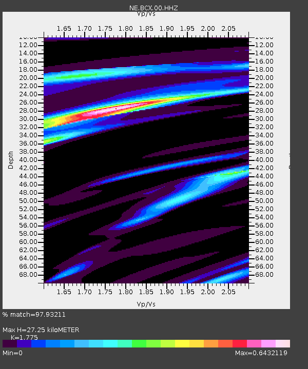
| Estimated Moho Depth: |
27.25 km |
| Estimated Crust Vp/Vs: |
1.77 |
| Assumed Crust Vp: |
6.419 km/s |
| Estimated Crust Vs: |
3.616 km/s |
| Estimated Crust Poisson's Ratio: |
0.27 |
|
| Radial Match: |
97.93211 % |
| Radial Bump: |
254 |
| Transverse Match: |
85.635315 % |
| Transverse Bump: |
400 |
| SOD ConfigId: |
2546091 |
| Insert Time: |
2018-03-02 23:42:41.605 +0000 |
| GWidth: |
2.5 |
| Max Bumps: |
400 |
| Tol: |
0.001 |
|

Signal To Noise
| Channel | StoN | STA | LTA |
| NE:BCX:00:HHZ:20180216T23:45:57.843994Z | 45.640263 | 1.1186855E-5 | 2.4510936E-7 |
| NE:BCX:00:HH1:20180216T23:45:57.843994Z | 28.014362 | 5.8244896E-6 | 2.0791083E-7 |
| NE:BCX:00:HH2:20180216T23:45:57.843994Z | 33.800674 | 6.916908E-6 | 2.0463817E-7 |
| Arrivals |
| Ps | 3.6 SECOND |
| PpPs | 11 SECOND |
| PsPs/PpSs | 14 SECOND |


