You are here: Home > Network List > US - United States National Seismic Network Stations List
> Station HAWA Hanford, Washington, USA > Earthquake Result Viewer
HAWA Hanford, Washington, USA - Earthquake Result Viewer
| Earthquake location: |
Oaxaca, Mexico |
| Earthquake latitude/longitude: |
16.4/-97.9 |
| Earthquake time(UTC): |
2018/02/16 (047) 23:39:44 GMT |
| Earthquake Depth: |
43 km |
| Earthquake Magnitude: |
7.5 Mi |
| Earthquake Catalog/Contributor: |
NEIC PDE/at |
|
| Network: |
US United States National Seismic Network |
| Station: |
HAWA Hanford, Washington, USA |
| Lat/Lon: |
46.39 N/119.53 W |
| Elevation: |
364 m |
|
| Distance: |
34.9 deg |
| Az: |
333.52 deg |
| Baz: |
141.806 deg |
| Ray Param: |
0.07740395 |
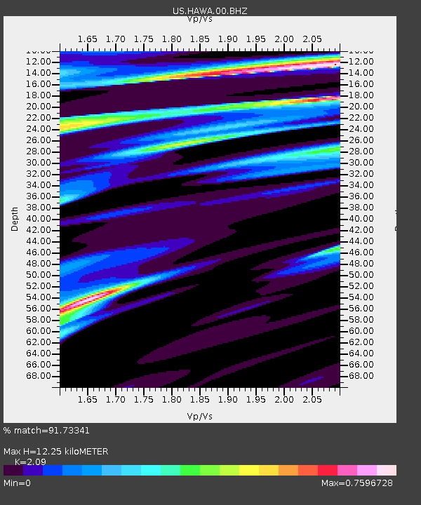
| Estimated Moho Depth: |
12.25 km |
| Estimated Crust Vp/Vs: |
2.09 |
| Assumed Crust Vp: |
6.419 km/s |
| Estimated Crust Vs: |
3.071 km/s |
| Estimated Crust Poisson's Ratio: |
0.35 |
|
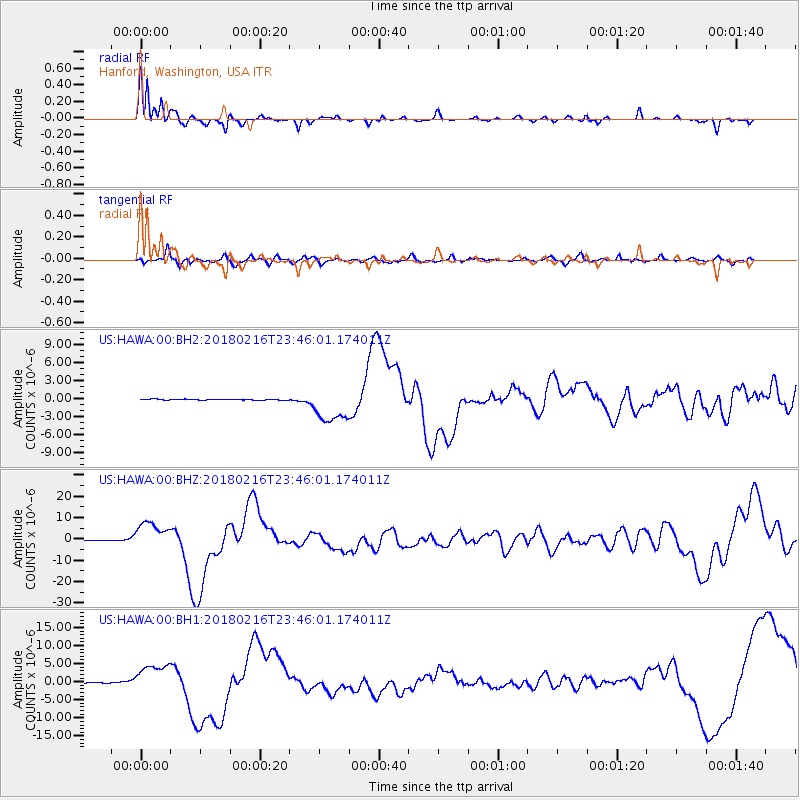
| Radial Match: |
91.73341 % |
| Radial Bump: |
272 |
| Transverse Match: |
69.24296 % |
| Transverse Bump: |
400 |
| SOD ConfigId: |
2546091 |
| Insert Time: |
2018-03-02 23:43:23.708 +0000 |
| GWidth: |
2.5 |
| Max Bumps: |
400 |
| Tol: |
0.001 |
|
Signal To Noise
| Channel | StoN | STA | LTA |
| US:HAWA:00:BHZ:20180216T23:46:01.174011Z | 63.143166 | 6.757051E-6 | 1.070116E-7 |
| US:HAWA:00:BH1:20180216T23:46:01.174011Z | 29.098783 | 4.123978E-6 | 1.417234E-7 |
| US:HAWA:00:BH2:20180216T23:46:01.174011Z | 39.225975 | 3.018414E-6 | 7.694937E-8 |
| Arrivals |
| Ps | 2.2 SECOND |
| PpPs | 5.5 SECOND |
| PsPs/PpSs | 7.7 SECOND |


