You are here: Home > Network List > NN - Western Great Basin/Eastern Sierra Nevada Stations List
> Station MOHS Mojave High School, LLNL/ANSS BB+SM w84gm > Earthquake Result Viewer
MOHS Mojave High School, LLNL/ANSS BB+SM w84gm - Earthquake Result Viewer
| Earthquake location: |
Vanuatu Islands |
| Earthquake latitude/longitude: |
-13.7/167.5 |
| Earthquake time(UTC): |
2021/08/31 (243) 13:26:58 GMT |
| Earthquake Depth: |
10 km |
| Earthquake Magnitude: |
5.3 Mww |
| Earthquake Catalog/Contributor: |
NEIC PDE/us |
|
| Network: |
NN Western Great Basin/Eastern Sierra Nevada |
| Station: |
MOHS Mojave High School, LLNL/ANSS BB+SM w84gm |
| Lat/Lon: |
36.25 N/115.14 W |
| Elevation: |
623 m |
|
| Distance: |
88.1 deg |
| Az: |
52.104 deg |
| Baz: |
251.58 deg |
| Ray Param: |
0.0428369 |
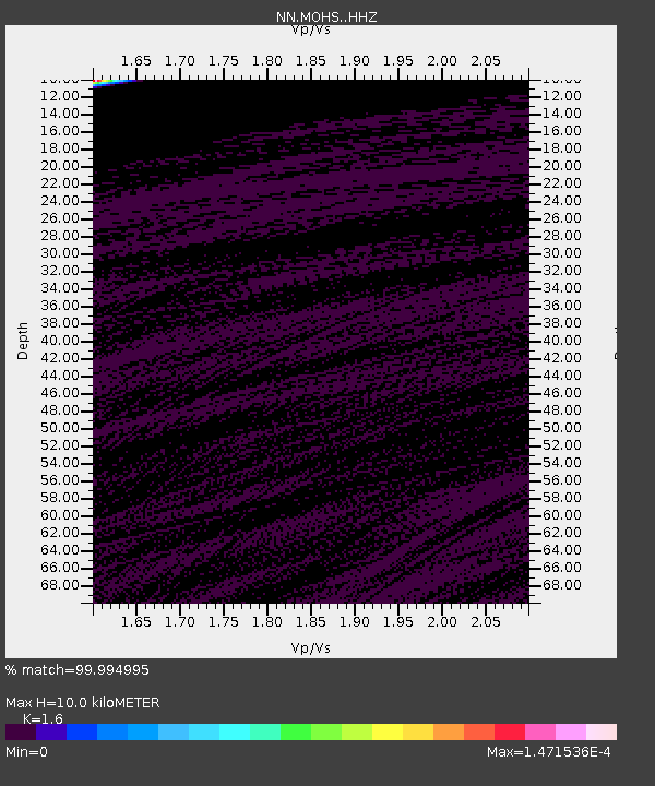
| Estimated Moho Depth: |
10.0 km |
| Estimated Crust Vp/Vs: |
1.60 |
| Assumed Crust Vp: |
6.276 km/s |
| Estimated Crust Vs: |
3.922 km/s |
| Estimated Crust Poisson's Ratio: |
0.18 |
|
| Radial Match: |
99.994995 % |
| Radial Bump: |
2 |
| Transverse Match: |
99.998314 % |
| Transverse Bump: |
2 |
| SOD ConfigId: |
25131211 |
| Insert Time: |
2021-09-14 13:38:05.705 +0000 |
| GWidth: |
2.5 |
| Max Bumps: |
400 |
| Tol: |
0.001 |
|

Signal To Noise
| Channel | StoN | STA | LTA |
| NN:MOHS: :HHZ:20210831T13:39:17.394987Z | 12.395494 | 1.0598857E-6 | 8.550572E-8 |
| NN:MOHS: :HHN:20210831T13:39:17.394987Z | 12.418507 | 7.9649635E-7 | 6.413785E-8 |
| NN:MOHS: :HHE:20210831T13:39:17.394987Z | 1.031981 | 1.6325108E-9 | 1.5819194E-9 |
| Arrivals |
| Ps | 1.0 SECOND |
| PpPs | 4.0 SECOND |
| PsPs/PpSs | 5.0 SECOND |


