You are here: Home > Network List > YL01 - Himalayan Nepal Tibet Experiment Stations List
> Station ILAM YL.ILAM > Earthquake Result Viewer
ILAM YL.ILAM - Earthquake Result Viewer
| Earthquake location: |
Mindanao, Philippines |
| Earthquake latitude/longitude: |
6.3/125.7 |
| Earthquake time(UTC): |
2002/01/01 (001) 11:29:22 GMT |
| Earthquake Depth: |
138 km |
| Earthquake Magnitude: |
5.9 MB, 6.3 MW, 6.3 MW |
| Earthquake Catalog/Contributor: |
WHDF/NEIC |
|
| Network: |
YL Himalayan Nepal Tibet Experiment |
| Station: |
ILAM YL.ILAM |
| Lat/Lon: |
26.91 N/87.92 E |
| Elevation: |
1181 m |
|
| Distance: |
41.3 deg |
| Az: |
304.138 deg |
| Baz: |
112.869 deg |
| Ray Param: |
0.073351756 |
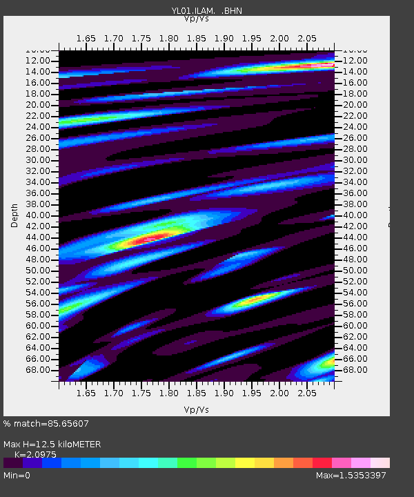
| Estimated Moho Depth: |
12.5 km |
| Estimated Crust Vp/Vs: |
2.10 |
| Assumed Crust Vp: |
6.236 km/s |
| Estimated Crust Vs: |
2.973 km/s |
| Estimated Crust Poisson's Ratio: |
0.35 |
|
| Radial Match: |
85.65607 % |
| Radial Bump: |
400 |
| Transverse Match: |
85.53467 % |
| Transverse Bump: |
400 |
| SOD ConfigId: |
16820 |
| Insert Time: |
2010-02-26 15:56:19.763 +0000 |
| GWidth: |
2.5 |
| Max Bumps: |
400 |
| Tol: |
0.001 |
|
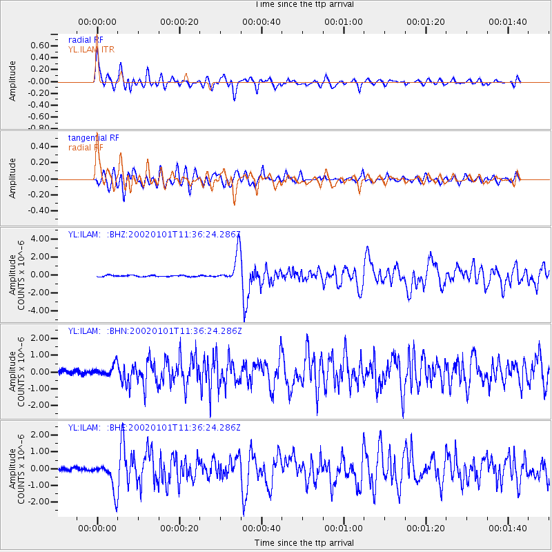
Signal To Noise
| Channel | StoN | STA | LTA |
| YL:ILAM: :BHN:20020101T11:36:24.286Z | 3.0546727 | 3.410502E-7 | 1.1164868E-7 |
| YL:ILAM: :BHE:20020101T11:36:24.286Z | 11.033119 | 8.9047285E-7 | 8.070908E-8 |
| YL:ILAM: :BHZ:20020101T11:36:24.286Z | 23.144405 | 1.7322882E-6 | 7.484695E-8 |
| Arrivals |
| Ps | 2.3 SECOND |
| PpPs | 5.9 SECOND |
| PsPs/PpSs | 8.2 SECOND |


