You are here: Home > Network List > UW - Pacific Northwest Regional Seismic Network Stations List
> Station UMAT Pilot Rock, OR, USA > Earthquake Result Viewer
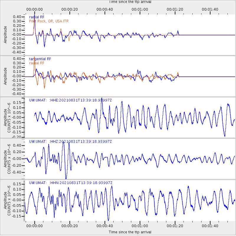
UMAT Pilot Rock, OR, USA - Earthquake Result Viewer
*The percent match for this event was below the threshold and hence no stack was calculated.
| Earthquake location: |
Vanuatu Islands |
| Earthquake latitude/longitude: |
-13.7/167.5 |
| Earthquake time(UTC): |
2021/08/31 (243) 13:26:58 GMT |
| Earthquake Depth: |
10 km |
| Earthquake Magnitude: |
5.3 Mww |
| Earthquake Catalog/Contributor: |
NEIC PDE/us |
|
| Network: |
UW Pacific Northwest Regional Seismic Network |
| Station: |
UMAT Pilot Rock, OR, USA |
| Lat/Lon: |
45.29 N/118.96 W |
| Elevation: |
1318 m |
|
| Distance: |
88.4 deg |
| Az: |
42.626 deg |
| Baz: |
248.799 deg |
| Ray Param: |
$rayparam |
*The percent match for this event was below the threshold and hence was not used in the summary stack. |
|
| Radial Match: |
77.37246 % |
| Radial Bump: |
366 |
| Transverse Match: |
55.815826 % |
| Transverse Bump: |
400 |
| SOD ConfigId: |
25131211 |
| Insert Time: |
2021-09-14 13:41:43.710 +0000 |
| GWidth: |
2.5 |
| Max Bumps: |
400 |
| Tol: |
0.001 |
|
Signal To Noise
| Channel | StoN | STA | LTA |
| UW:UMAT: :HHZ:20210831T13:39:18.93997Z | 3.0051084 | 1.340856E-7 | 4.461922E-8 |
| UW:UMAT: :HHN:20210831T13:39:18.93997Z | 0.9344017 | 6.5313145E-8 | 6.989836E-8 |
| UW:UMAT: :HHE:20210831T13:39:18.93997Z | 1.8170074 | 5.5023726E-8 | 3.028261E-8 |
| Arrivals |
| Ps | |
| PpPs | |
| PsPs/PpSs | |


