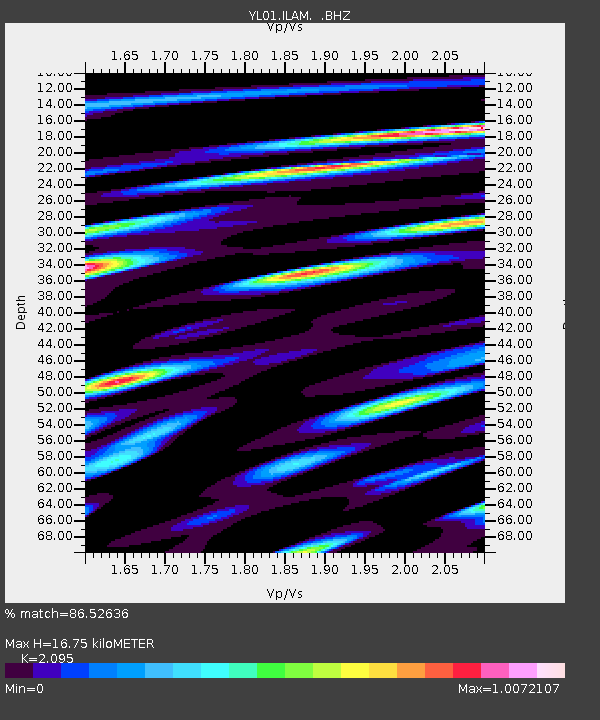
ILAM YL.ILAM - Earthquake Result Viewer
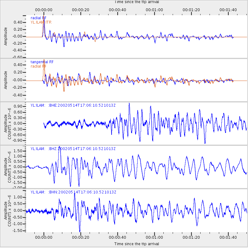
Earthquake location: Mid-Indian Ridge
Earthquake latitude/longitude: -36.5/78.9
Earthquake time(UTC): 2002/05/14 (134) 16:56:10 GMT
Earthquake Depth: 10 km
Earthquake Magnitude: 5.6 MB, 6.1 MS, 6.3 MW, 6.1 MW
Earthquake Catalog/Contributor: WHDF/NEIC
Network: YL Himalayan Nepal Tibet Experiment
Station: ILAM YL.ILAM
Lat/Lon: 26.91 N/87.92 E
Elevation: 1181 m
Distance: 63.7 deg
Az: 8.958 deg
Baz: 188.076 deg
Ray Param: 0.059435993
Estimated Moho Depth: 16.75 km
Estimated Crust Vp/Vs: 2.10
Assumed Crust Vp: 6.236 km/s
Estimated Crust Vs: 2.977 km/s
Estimated Crust Poisson's Ratio: 0.35
Radial Match: 86.52636 %
Radial Bump: 400
Transverse Match: 83.96419 %
Transverse Bump: 400
SOD ConfigId: 16844
Insert Time: 2010-02-26 15:56:24.476 +0000
GWidth: 2.5
Max Bumps: 400
Tol: 0.001

Signal To Noise

ChannelStoNSTALTA
YL:ILAM: :BHZ:20020514T17:06:10.521013Z2.64669852.7589743E-71.04242105E-7
YL:ILAM: :BHN:20020514T17:06:10.521013Z1.1472731.0933892E-79.530333E-8
YL:ILAM: :BHE:20020514T17:06:10.521013Z0.95280248.609023E-89.035475E-8
Arrivals
Ps3.0 SECOND
PpPs8.0 SECOND
PsPs/PpSs11 SECOND