You are here: Home > Network List > WI - West Indies IPGP Network Stations List
> Station MAGL Barre de l'ile, Marie-Galante, Guadeloupe > Earthquake Result Viewer
MAGL Barre de l'ile, Marie-Galante, Guadeloupe - Earthquake Result Viewer
| Earthquake location: |
Oaxaca, Mexico |
| Earthquake latitude/longitude: |
16.4/-97.9 |
| Earthquake time(UTC): |
2018/02/16 (047) 23:39:44 GMT |
| Earthquake Depth: |
43 km |
| Earthquake Magnitude: |
7.5 Mi |
| Earthquake Catalog/Contributor: |
NEIC PDE/at |
|
| Network: |
WI West Indies IPGP Network |
| Station: |
MAGL Barre de l'ile, Marie-Galante, Guadeloupe |
| Lat/Lon: |
15.95 N/61.28 W |
| Elevation: |
159 m |
|
| Distance: |
35.1 deg |
| Az: |
85.471 deg |
| Baz: |
275.939 deg |
| Ray Param: |
0.07728353 |
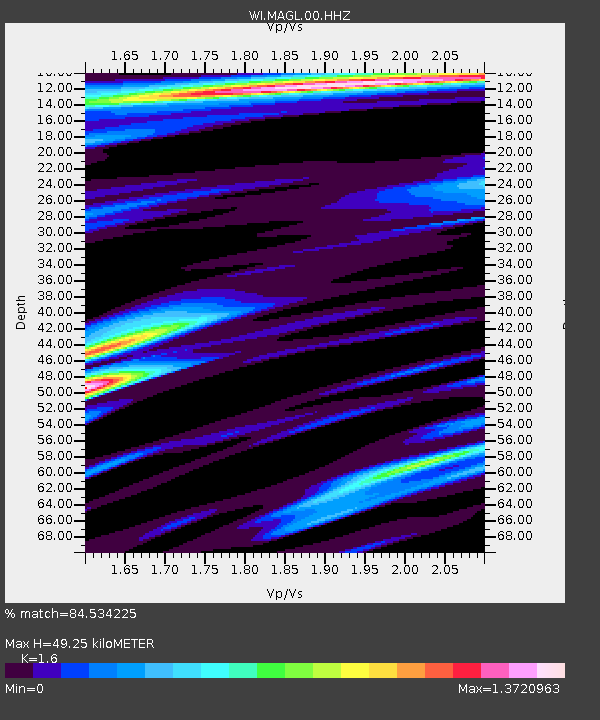
| Estimated Moho Depth: |
49.25 km |
| Estimated Crust Vp/Vs: |
1.60 |
| Assumed Crust Vp: |
5.88 km/s |
| Estimated Crust Vs: |
3.675 km/s |
| Estimated Crust Poisson's Ratio: |
0.18 |
|
| Radial Match: |
84.534225 % |
| Radial Bump: |
343 |
| Transverse Match: |
79.0201 % |
| Transverse Bump: |
400 |
| SOD ConfigId: |
2546091 |
| Insert Time: |
2018-03-02 23:43:53.082 +0000 |
| GWidth: |
2.5 |
| Max Bumps: |
400 |
| Tol: |
0.001 |
|
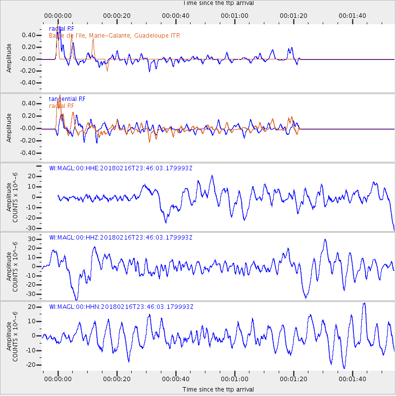
Signal To Noise
| Channel | StoN | STA | LTA |
| WI:MAGL:00:HHZ:20180216T23:46:03.179993Z | 5.996448 | 1.0964474E-5 | 1.8284949E-6 |
| WI:MAGL:00:HHN:20180216T23:46:03.179993Z | 1.8327512 | 2.5177924E-6 | 1.3737775E-6 |
| WI:MAGL:00:HHE:20180216T23:46:03.179993Z | 5.219355 | 8.058907E-6 | 1.5440427E-6 |
| Arrivals |
| Ps | 5.4 SECOND |
| PpPs | 20 SECOND |
| PsPs/PpSs | 26 SECOND |


