You are here: Home > Network List > YL01 - Himalayan Nepal Tibet Experiment Stations List
> Station ILAM YL.ILAM > Earthquake Result Viewer
ILAM YL.ILAM - Earthquake Result Viewer
| Earthquake location: |
Southern Greece |
| Earthquake latitude/longitude: |
36.6/24.3 |
| Earthquake time(UTC): |
2002/05/21 (141) 20:53:29 GMT |
| Earthquake Depth: |
97 km |
| Earthquake Magnitude: |
5.4 MB, 5.6 MD |
| Earthquake Catalog/Contributor: |
WHDF/NEIC |
|
| Network: |
YL Himalayan Nepal Tibet Experiment |
| Station: |
ILAM YL.ILAM |
| Lat/Lon: |
26.91 N/87.92 E |
| Elevation: |
1181 m |
|
| Distance: |
54.1 deg |
| Az: |
81.002 deg |
| Baz: |
297.15 deg |
| Ray Param: |
0.06537005 |
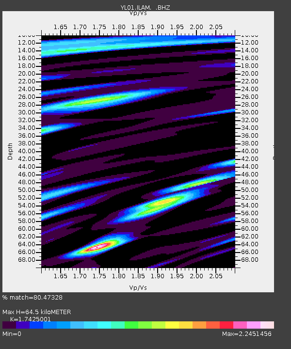
| Estimated Moho Depth: |
64.5 km |
| Estimated Crust Vp/Vs: |
1.74 |
| Assumed Crust Vp: |
6.236 km/s |
| Estimated Crust Vs: |
3.579 km/s |
| Estimated Crust Poisson's Ratio: |
0.25 |
|
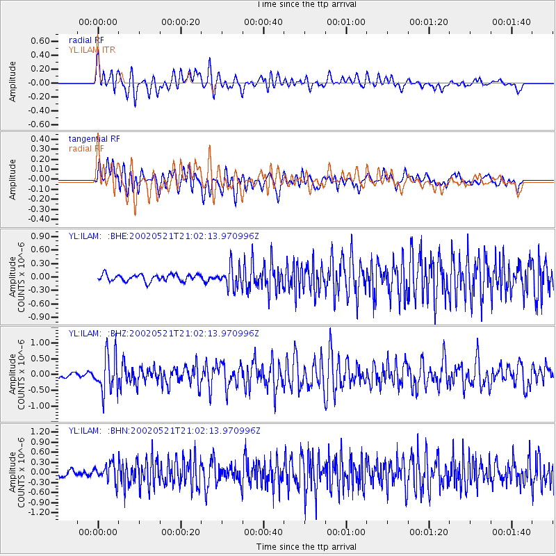
| Radial Match: |
80.47328 % |
| Radial Bump: |
400 |
| Transverse Match: |
64.9576 % |
| Transverse Bump: |
400 |
| SOD ConfigId: |
16844 |
| Insert Time: |
2010-02-26 15:56:26.208 +0000 |
| GWidth: |
2.5 |
| Max Bumps: |
400 |
| Tol: |
0.001 |
|
Signal To Noise
| Channel | StoN | STA | LTA |
| YL:ILAM: :BHZ:20020521T21:02:13.970996Z | 5.802589 | 5.9916897E-7 | 1.03258905E-7 |
| YL:ILAM: :BHN:20020521T21:02:13.970996Z | 2.0058706 | 2.682614E-7 | 1.3373814E-7 |
| YL:ILAM: :BHE:20020521T21:02:13.970996Z | 3.1612003 | 2.4069143E-7 | 7.613926E-8 |
| Arrivals |
| Ps | 8.1 SECOND |
| PpPs | 27 SECOND |
| PsPs/PpSs | 35 SECOND |


