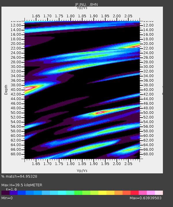
JNU Oita Nakatsue - Earthquake Result Viewer

Earthquake location: Samoa Islands Region
Earthquake latitude/longitude: -15.5/-172.1
Earthquake time(UTC): 2009/09/29 (272) 17:48:10 GMT
Earthquake Depth: 18 km
Earthquake Magnitude: 7.1 MB, 8.1 MS, 8.1 MW, 8.0 MW
Earthquake Catalog/Contributor: WHDF/NEIC
Network: JP Japan Meteorological Agency Seismic Network
Station: JNU Oita Nakatsue
Lat/Lon: 33.12 N/130.88 E
Elevation: 540 m
Distance: 72.8 deg
Az: 312.522 deg
Baz: 122.135 deg
Ray Param: 0.053417504
Estimated Moho Depth: 39.5 km
Estimated Crust Vp/Vs: 1.60
Assumed Crust Vp: 6.468 km/s
Estimated Crust Vs: 4.042 km/s
Estimated Crust Poisson's Ratio: 0.18
Radial Match: 94.95328 %
Radial Bump: 388
Transverse Match: 85.26739 %
Transverse Bump: 400
SOD ConfigId: 2622
Insert Time: 2010-03-09 12:17:07.410 +0000
GWidth: 2.5
Max Bumps: 400
Tol: 0.001

Signal To Noise

ChannelStoNSTALTA
JP:JNU: :BHN:20090929T17:59:07.00001Z4.55194571.6967614E-63.7275518E-7
JP:JNU: :BHE:20090929T17:59:07.00001Z1.07228162.41626E-72.253382E-7
JP:JNU: :BHZ:20090929T17:59:07.00001Z2.9551625.1784644E-71.7523453E-7
Arrivals
Ps3.8 SECOND
PpPs15 SECOND
PsPs/PpSs19 SECOND