ILAM YL.ILAM - Earthquake Result Viewer
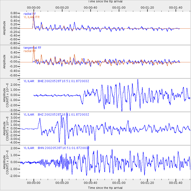
Earthquake location: Taiwan Region
Earthquake latitude/longitude: 24.1/122.3
Earthquake time(UTC): 2002/05/28 (148) 16:45:17 GMT
Earthquake Depth: 33 km
Earthquake Magnitude: 5.8 MB, 5.9 MS, 6.0 MW, 6.0 MW
Earthquake Catalog/Contributor: WHDF/NEIC
Network: YL Himalayan Nepal Tibet Experiment
Station: ILAM YL.ILAM
Lat/Lon: 26.91 N/87.92 E
Elevation: 1181 m
Distance: 31.1 deg
Az: 282.588 deg
Baz: 87.516 deg
Ray Param: 0.07913434
Estimated Moho Depth: 34.25 km
Estimated Crust Vp/Vs: 1.89
Assumed Crust Vp: 6.236 km/s
Estimated Crust Vs: 3.295 km/s
Estimated Crust Poisson's Ratio: 0.31
Radial Match: 81.42334 %
Radial Bump: 400
Transverse Match: 74.126564 %
Transverse Bump: 400
SOD ConfigId: 16844
Insert Time: 2010-02-26 15:56:27.967 +0000
GWidth: 2.5
Max Bumps: 400
Tol: 0.001

Signal To Noise

ChannelStoNSTALTA
YL:ILAM: :BHZ:20020528T16:51:01.872003Z21.4316221.1266986E-65.257179E-8
YL:ILAM: :BHN:20020528T16:51:01.872003Z1.39483839.084706E-86.513089E-8
YL:ILAM: :BHE:20020528T16:51:01.872003Z9.3004517.0786876E-77.6111235E-8
Arrivals
Ps5.3 SECOND
PpPs15 SECOND
PsPs/PpSs20 SECOND