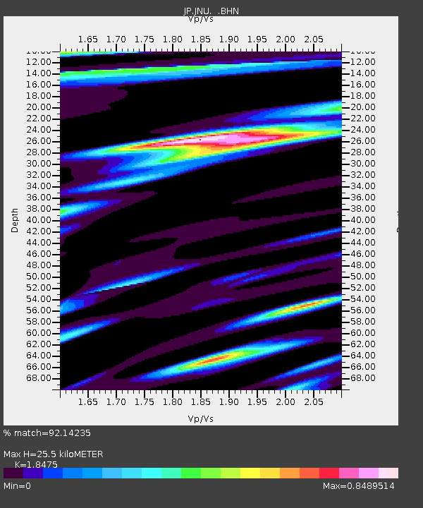
JNU Oita Nakatsue - Earthquake Result Viewer

Earthquake location: Kermadec Islands Region
Earthquake latitude/longitude: -31.2/-176.9
Earthquake time(UTC): 2008/12/09 (344) 06:23:59 GMT
Earthquake Depth: 18 km
Earthquake Magnitude: 6.2 MB, 6.7 MS, 6.8 MW, 6.7 MW
Earthquake Catalog/Contributor: WHDF/NEIC
Network: JP Japan Meteorological Agency Seismic Network
Station: JNU Oita Nakatsue
Lat/Lon: 33.12 N/130.88 E
Elevation: 540 m
Distance: 80.8 deg
Az: 317.801 deg
Baz: 136.711 deg
Ray Param: 0.04801994
Estimated Moho Depth: 25.5 km
Estimated Crust Vp/Vs: 1.85
Assumed Crust Vp: 6.468 km/s
Estimated Crust Vs: 3.501 km/s
Estimated Crust Poisson's Ratio: 0.29
Radial Match: 92.14235 %
Radial Bump: 400
Transverse Match: 81.94143 %
Transverse Bump: 400
SOD ConfigId: 2658
Insert Time: 2010-03-09 12:17:23.910 +0000
GWidth: 2.5
Max Bumps: 400
Tol: 0.001

Signal To Noise

ChannelStoNSTALTA
JP:JNU: :BHN:20081209T06:35:40.799011Z10.6407112.1046858E-61.977956E-7
JP:JNU: :BHE:20081209T06:35:40.799011Z2.15637784.5916616E-72.1293401E-7
JP:JNU: :BHZ:20081209T06:35:40.799011Z3.29527126.323327E-71.9189096E-7
Arrivals
Ps3.4 SECOND
PpPs11 SECOND
PsPs/PpSs14 SECOND