You are here: Home > Network List > NE - New England Seismic Network Stations List
> Station EMMW Machias, ME, USA > Earthquake Result Viewer
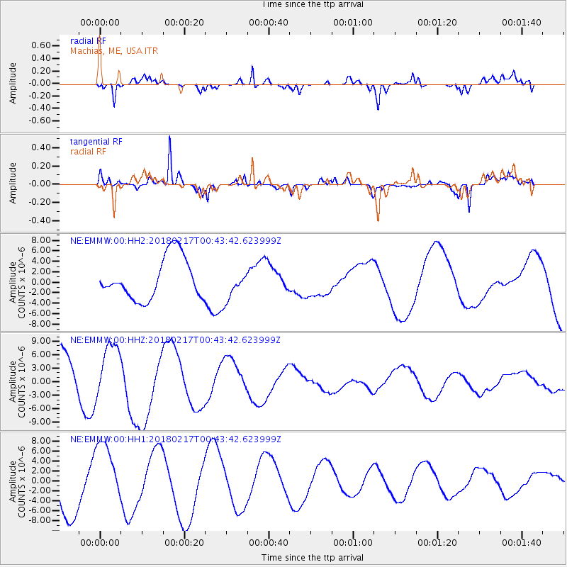
EMMW Machias, ME, USA - Earthquake Result Viewer
*The percent match for this event was below the threshold and hence no stack was calculated.
| Earthquake location: |
Oaxaca, Mexico |
| Earthquake latitude/longitude: |
16.2/-97.8 |
| Earthquake time(UTC): |
2018/02/17 (048) 00:36:53 GMT |
| Earthquake Depth: |
8.9 km |
| Earthquake Magnitude: |
5.8 Mww |
| Earthquake Catalog/Contributor: |
NEIC PDE/us |
|
| Network: |
NE New England Seismic Network |
| Station: |
EMMW Machias, ME, USA |
| Lat/Lon: |
44.71 N/67.46 W |
| Elevation: |
35 m |
|
| Distance: |
38.2 deg |
| Az: |
35.579 deg |
| Baz: |
231.622 deg |
| Ray Param: |
$rayparam |
*The percent match for this event was below the threshold and hence was not used in the summary stack. |
|
| Radial Match: |
83.30107 % |
| Radial Bump: |
400 |
| Transverse Match: |
93.354126 % |
| Transverse Bump: |
365 |
| SOD ConfigId: |
2546091 |
| Insert Time: |
2018-03-03 00:40:54.293 +0000 |
| GWidth: |
2.5 |
| Max Bumps: |
400 |
| Tol: |
0.001 |
|
Signal To Noise
| Channel | StoN | STA | LTA |
| NE:EMMW:00:HHZ:20180217T00:43:42.623999Z | 1.0650321 | 6.1746405E-6 | 5.79761E-6 |
| NE:EMMW:00:HH1:20180217T00:43:42.623999Z | 1.5019168 | 6.590187E-6 | 4.387851E-6 |
| NE:EMMW:00:HH2:20180217T00:43:42.623999Z | 0.75064796 | 2.9429325E-6 | 3.920523E-6 |
| Arrivals |
| Ps | |
| PpPs | |
| PsPs/PpSs | |


