You are here: Home > Network List > YL01 - Himalayan Nepal Tibet Experiment Stations List
> Station ILAM YL.ILAM > Earthquake Result Viewer
ILAM YL.ILAM - Earthquake Result Viewer
| Earthquake location: |
Bonin Islands, Japan Region |
| Earthquake latitude/longitude: |
27.6/139.8 |
| Earthquake time(UTC): |
2002/06/03 (154) 09:15:00 GMT |
| Earthquake Depth: |
489 km |
| Earthquake Magnitude: |
5.0 MB, 5.9 MW, 5.9 MW |
| Earthquake Catalog/Contributor: |
WHDF/NEIC |
|
| Network: |
YL Himalayan Nepal Tibet Experiment |
| Station: |
ILAM YL.ILAM |
| Lat/Lon: |
26.91 N/87.92 E |
| Elevation: |
1181 m |
|
| Distance: |
45.8 deg |
| Az: |
281.729 deg |
| Baz: |
76.767 deg |
| Ray Param: |
0.068774365 |
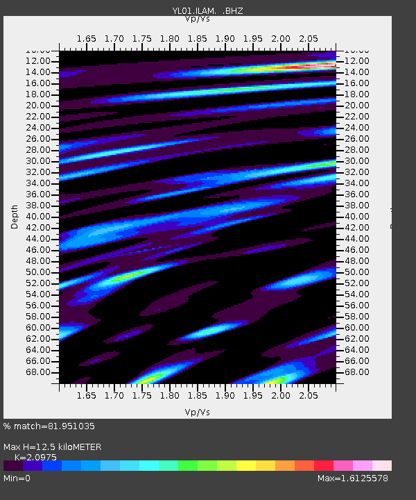
| Estimated Moho Depth: |
12.5 km |
| Estimated Crust Vp/Vs: |
2.10 |
| Assumed Crust Vp: |
6.236 km/s |
| Estimated Crust Vs: |
2.973 km/s |
| Estimated Crust Poisson's Ratio: |
0.35 |
|
| Radial Match: |
81.951035 % |
| Radial Bump: |
400 |
| Transverse Match: |
75.100586 % |
| Transverse Bump: |
400 |
| SOD ConfigId: |
16844 |
| Insert Time: |
2010-02-26 15:56:29.378 +0000 |
| GWidth: |
2.5 |
| Max Bumps: |
400 |
| Tol: |
0.001 |
|
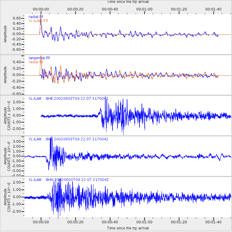
Signal To Noise
| Channel | StoN | STA | LTA |
| YL:ILAM: :BHZ:20020603T09:22:07.317004Z | 12.519747 | 7.544881E-7 | 6.0263844E-8 |
| YL:ILAM: :BHN:20020603T09:22:07.317004Z | 1.5518447 | 1.3518977E-7 | 8.7115524E-8 |
| YL:ILAM: :BHE:20020603T09:22:07.317004Z | 4.625227 | 3.4315664E-7 | 7.419239E-8 |
| Arrivals |
| Ps | 2.3 SECOND |
| PpPs | 5.9 SECOND |
| PsPs/PpSs | 8.2 SECOND |


