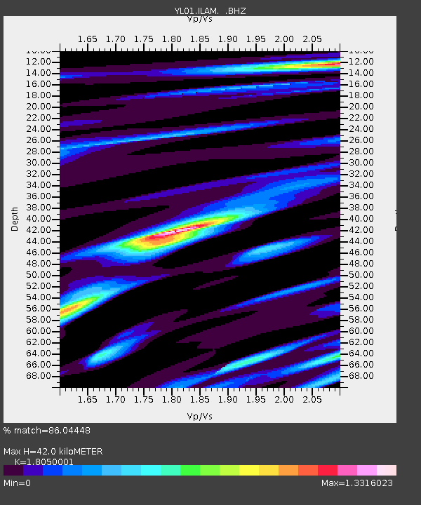
ILAM YL.ILAM - Earthquake Result Viewer
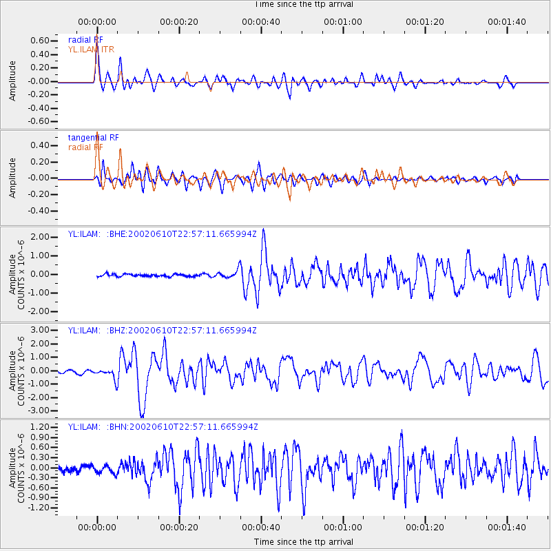
Earthquake location: W. Caroline Islands, Micronesia
Earthquake latitude/longitude: 11.0/140.7
Earthquake time(UTC): 2002/06/10 (161) 22:48:36 GMT
Earthquake Depth: 33 km
Earthquake Magnitude: 5.9 MB, 5.9 MS, 6.1 MW, 6.0 MW
Earthquake Catalog/Contributor: WHDF/NEIC
Network: YL Himalayan Nepal Tibet Experiment
Station: ILAM YL.ILAM
Lat/Lon: 26.91 N/87.92 E
Elevation: 1181 m
Distance: 52.0 deg
Az: 295.543 deg
Baz: 97.174 deg
Ray Param: 0.0669831
Estimated Moho Depth: 42.0 km
Estimated Crust Vp/Vs: 1.81
Assumed Crust Vp: 6.236 km/s
Estimated Crust Vs: 3.455 km/s
Estimated Crust Poisson's Ratio: 0.28
Radial Match: 86.04448 %
Radial Bump: 400
Transverse Match: 81.748665 %
Transverse Bump: 400
SOD ConfigId: 16844
Insert Time: 2010-02-26 15:56:31.218 +0000
GWidth: 2.5
Max Bumps: 400
Tol: 0.001

Signal To Noise

ChannelStoNSTALTA
YL:ILAM: :BHZ:20020610T22:57:11.665994Z4.9335244.1413247E-78.3942524E-8
YL:ILAM: :BHN:20020610T22:57:11.665994Z1.49353721.1892287E-77.962498E-8
YL:ILAM: :BHE:20020610T22:57:11.665994Z3.80200432.3045641E-76.0614454E-8
Arrivals
Ps5.7 SECOND
PpPs18 SECOND
PsPs/PpSs24 SECOND